|
||

|

|
|

|
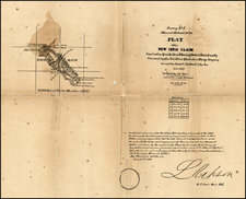
First and Only Edition of One of the Earliest Obtainable Separate Maps of Los Angeles.
Rare separately-issued map of the central part of Los Angeles, one of the earliest obtainable maps of the heart of the city.
The map was issued as a promotional item for Stoll & Thayer, who were among the earliest booksellers, stationers, and map publishers working in Los Angeles. The map includes a detailed table of references (showing the names of public and private buildings, parks, etc.), along with a table showing rail lines, sprinkling hydrants, graded streets, sewer lines, and other important details.
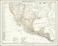
Stoll & Thayer's Map was issued during a mini-boom in Los Angeles real estate and consequently in L.A. cartographic output. The mid-1880s mapping era started in 1884 with H.J. Stevenson's Map of the City of Los Angeles California... 1884, followed by the present, more focused, Stoll & Thayer map. The city was comprehensively surveyed by the City Surveyor in 1886, after the present map was issued. That project resulted in Valentine James Rowan's Map of the City of Los Angeles... 1887, commonly called the Rowan and Koeberle Map, which Valentine completed when he was 23-years-old. The 1887 Rowan map marked the top of the L.A. real estate boom, and when it subsided so did map production for some years. These three maps are essentially the earliest printed Los Angeles maps obtainable to a collector.
The Thayer in Stoll & Thayer had been involved in the production of the Hansen-Hancock-Ord composite map in circa 1875, as part of the firm Bancroft and Thayer.
Rarity
One of the earliest obtainable maps of Los Angeles and one of the rarest. OCLC locates only 2 examples (Huntington Library and Bancroft Library). An 1886 cover-titled Stoll & Thayer's Reference Street Map of the City of Los Angeles is recorded in only one example by OCLC (Library of Congress).
It was previously assumed that the map was issued in two editions, in 1885 and 1886, however, having examined the extant copies and contemporary advertisements, it is clear that the map first appeared in January of 1886, while the copyright date referenced the map's preparation in 1885. Between the so-called 1885 and 1886 editions, there is no difference in the map itself; some copies simply have covers dated 1886 whereas other copies have no covers. The map was first advertised in The Los Angeles Times on January 19, 1886: "SOMETHING NEW, A Reference Map of Los Angeles City, Published by STOLL & THAYER, NADEAU BLOCK, PRICE 25c. For sale at the book stores." The map was printed in Boston by the Heliotype Printing Company, before being sent to Los Angeles for sale.