


|
||

|

|
|

|
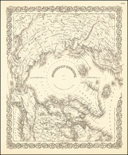
First Printed Map of the Northwest Passage -- Northwest Passage Finally Revealed
Exceedingly rare map of the Northwest Passage as delineated by the voyages sent in search of the lost Franklin expedition.
Johnston's map is the first commercially published map of the Northwest Pasage. Issued thirteen days after the Admiralty edition of the map referenced in Johnston's title, this second edition, as Johnston calls it, is signifcantly rarer than the first edition, with only two known institutional examples.
Johnston's map is also much more detailed than the Admiralty edition. It contains numerous inland details and many more toponyms than its predecessor. It also provides prospective navigational details omitted by the Admiralty chart, including Admiralty Inlet, Scott Inlet and several supposed channels along the west coast of Baffin Bay, among others.
As noted in the title, Sir Edward Belcher is one of nine polar explorers whose coastal encounters are marked; they can be deciphered with a color-coded key below the title. These include James Ross (1848-9), John Richardson (1848-9), McClure (1850), Austin (1850), Penny (1850), Rae (1851) Kennedy (1852), Inglefield (1852-3) and Belcher (1852-53).
Earlier expeditions are also noted within the map; for example, “Franklin’s Discoveries 1825” refer to his two overland expeditions (1819-1822, 1825-1827). The “Parry Islands (discovered 1819)” were the result of an expedition led by Edward Perry, who led three northern voyages between 1819 and 1825.
Extending slighly further west than the Admiralty edition, the map stretches from Baffin Bay to the Bering Strait, the better to the see the voyages entering the area from both east and west. To the south is mainland North America, with Russian America—complete with an inland fort—divided from British Canada by a dotted boundary line. This boundary was negotiated at the Anglo-Russian Convention of 1825, where the Treaty of St. Petersburg set the limits of the empires’ reaches on the continent.
Inland there is much detail including rivers, trading posts, and tribal names. Some details, like the Yukon River and the McKenzie River, with the Hudson’s Bay Company post Fort McPherson, are boldly marked. Others are printed in a lighter ink, indicating that their final locations and outlines are not fully corroborated. This tentative geography extends to the seas as well; there are supposed inlets and channels between still unmapped islands southwest of Baffin Bay.
The main focus is on the passage that runs through the center of the chart, from Baffin Bay in the east, through Lancaster Sound and the Barrow Strait, into the Melville Strait, then around Baring Island (on its east or west side), and along the north coast of Alaska until one turns south through the Bering Strait. It was a perilous route, to be sure, but one that was navigable in the right season and if the ice was not too dense and extensive.
Helping to trace this route are several tracks. A solid line shows the voyage of the HMS Investigator from the Bering Strait east and around Baring Island from 1850-1853—the ship was stuck in the ice for all of 1852. Then, a dotted line heads off from their winter quarters eastward starting in April 1853. These are the sledge parties that left the Investigator in search of rescue. These “Traveling Parties,” as they are called on the map, made it to Beechey Island, where they met the HMS Phoenix in August 1853 and sailed home to England. The track of the Phoenix is also on the map.
Another track is a dotted line along the north coast of Alaska, a bit closer to shore than that of the Investigator. These are the boats of the HMS Plover, which was under the command of Thomas Moore. Moore, along with Henry Kellet in the HMS Herald, were part of the first expeditions sent to find Franklin from 1848-50. They were to wait for him in the western reaches of the passage, if he had gotten through. Kellett and the Herald were the last ship to see Investigator before it disappeared for three years, and Kellett would return to the Arctic in command of the famous HMS Resolute as part of Edward Belcher’s Franklin search expedition in 1852.
As indicated in the title, this second edition was based on Admiralty charts. The first edition of the map was prepared by E. A. Inglefield, who commanded the HMS Phoenix on its 1852-3 voyage. It was drawn by W. H. Fawkener, second master. Fawkener later served in the Crimean War, where he was awarded a Crimean War Medal. The original manuscript of the map is held at the National Maritime Museum, Greenwich (G285:4/36).
Interestingly, the title especially indicates that this edition includes the findings of Edward Belcher, who abandoned four ships in the ice, including the HMS Resolute (of Resolute desk fame). However, Belcher’s track was included on the first edition as well.
The Franklin expedition
The exploratory tracks included here were sent out in search of what happened to the lost ships of Sir John Franklin, the HMS Erebus and HMS Terror. They also hoped to find the Northwest Passage, as all voyages to the area had for centuries.
The nineteenth century marked a high point in the interest in finding an Arctic route to China. Earlier expeditions included that of John Ross, who made it to Baffin Bay and Lancaster Sound. Ross thought the Sound only an inlet, and went no further. He was followed by a voyage led by Edward Parry, who had been with Ross, in 1819. Parry wintered at Melville Island, gaining him an Admiralty prize for passing the 110th meridian west. On his second voyage, 1821-23, he probed the far north reaches of Hudson Bay. One his third voyage, of 1824-25, he searched for the Northwest Passage in the Prince Regent Inlet. Ross also returned to the Arctic, but neither man located the passage.
Franklin himself had already sought the elusive feature. He led overland expeditions in 1819-1822 and 1825-27. While the first voyage was marked by privation, the second saw Franklin and his men chart over 1,000 miles of Arctic coastline. Other overland expeditions also made contributions, such as those of George Back (1833-35) and Peter Dease and Thomas Simpson (1837-9).
Franklin was a career naval officer who participated in the Battle of Trafalgar at the age of 21. Most of his career was spent in Arctic exploration, however; Franklin participated in three Arctic expeditions before his fateful final foray. First, he served in the Dorothea, under Captain Buchan, and then was put in command of the Trent while they tried to reach the North Pole. Then, he led the two aforementioned overland expeditions.
In 1845, Franklin set out in command of Terror and Erebus. He had suggested the voyage in search of the Northwest Passage and the government fit out the ships with state-of-the-art technology and instruments. They left Greenhithe on May 19, 1845 and were sighted by a whaler off of Baffin Island in late July. After that, the ships were never seen afloat again, nor were the men seen alive.
By late 1847, it was clear that the expedition was in trouble or even lost. No less than 39 missions set out to find his men and ships over several decades; they hailed from Britain, the United States, France, and other countries. Many were spurred on by the advocacy of Jane Franklin, who worked tirelessly to raise funds and interest in finding her husband.
Later voyages pieced together a rough approximation of what happened to Terror and Erebus. The ships sailed up the Wellington Channel and then headed south toward Beechey Island, where they wintered. In spring 1846, the ships reached the northernmost point of King William Island, but then were trapped in the ice in the McClintock Channel.
By the spring of 1847, a small party reached Point Victory by traveling over the ice. There, they left a notice of their progress. John Franklin died in June of that year. The ships, still in the ice, were pulled south. The new commander of the expedition, Captain Crozier, decided to abandon the vessels. He updated the Point Victory note before the 105 survivors set out for the Great Fish River; most died on the march, near the west coast of King William Island. After that, all trace of them vanished.
The search for the Franklin expedition
Arctic voyages typically lasted multiple years, so initially there was no alarm when Franklin and his ships did not return. By 1847, however, Lady Jane Franklin began to worry at the expedition’s absence and lobbied the Admiralty to plan rescue voyages to search for the Terror and Erebus. Charles Dickens, the famous author, was one of Lady Jane’s supporters.
Sir James Clark Ross, the nephew of Arctic explorer John Ross, had previously commanded the Erebus and the Terror on an Antarctic voyage to take magnetic observations. In 1848, he set off north to find Franklin. Ross only reached the northeast tip of Somerset Island and decided that Franklin could not have gone through Peel Sound; in fact, Franklin had gone through the Sound in 1846.
Another early effort was led by Sir John Richardson and John Rae. An overland expedition, they probed the areas near the Mackenzie and Coppermine Rivers, where Franklin had proposed to explore. Richardson had previously been in the area on an earlier expedition that coincided with Franklin’s overland expeditions.
Horatio Austin, who had also previously been on Arctic expeditions, was put in command of the HMS Resolute and ordered to search for John Franklin. He traveled through Baffin Bay and Lancaster Sound. One of his crew, Erasmus Ommanney, found evidence that Franklin’s men had indeed reached the Arctic.
William Penny, a Scottish shipmaster and whaler, also joined the hunt. He searched for Franklin on whaling ships in 1847 and 1849, but was thwarted by ice. In 1850, backed by Lady Franklin, he again led a search in Jones Sound and the Wellington Channel. In the HMS Lady Franklin and Sophia, Penny combined his efforts with Austin’s at Beechey Island. There, they found three graves of Franklin’s men. Eventually he and Austin quarreled and he returned to Scotland.
John Rae was a physician who served as the surgeon at Hudson’s Bay Company’s post Moose Factory, on James Bay. His first Arctic exploration expedition was in 1846-7, when Franklin was still presumed alive. In 1848, he was made second-in-command on Richardson’s expedition, mentioned above. In 1849, he went back into the employ of the Hudson’s Bay company in the Mackenzie District. In 1851, Rae led another search for Franklin during which he traveled 5,300 miles and mapped 700 miles of the southern coast of Victoria Island. On his fourth expedition (1853-4), he surveyed Boothia Peninsula, proved King William Land to be an island, and interviewed Inuit peoples who gave him news of the tragic end of Franklin’s expedition.
Lady Franklin continued to advocate on her husband’s behalf, even if he was now presumed dead. She sponsored her own expedition in 1851, led by William Kennedy. Kennedy, the son a Hudson’s Bay Company factor and an English/Cree woman, and a fur trader himself, was well acquainted with the Arctic. While he did not find Franklin, he did gather more on the flora and fauna of the Arctic than any previous expedition, as well as surveyed new areas.
Edward Augustus Inglefield was a naval officer who led two Arctic expeditions in search of Franklin. The first, in the Isabel, Lady Franklin’s ship, charted much of Baffin Bay, Lancaster Sound, and Smith Sound. The second voyage, in HMS Phoenix, was meant to resupply Edward Belcher’s troubled expedition.
Edward Belcher was an accomplished naval surveyor and, in 1852, he was appointed commander of the largest Franklin search mission. In addition, he was to search for the voyage of McClure, which had seeming disappeared. McClure had departed in 1850 to approach the Northwest Passage via the Bering Strait. Separated from his accompanying vessel, McClure passed through the Barrow Strait. He then discovered the Prince of Wales Strait, beyond Parry Sound, where his ship was frozen in the ice. While his ship was stuck fast, McClure continued with sledges overland. He crested a hill and saw land and a body of water previously discovered by Parry—McClure had found the passage at last.
However, McClure had been out of touch with Britain since 1850. Belcher was given a squadron of five ships—HMS Assistance, HMS Resolute, HMS North Star, Pioneer, and Intrepid. He went to Wellington Channel to seek news of Franklin, while Henry Kellett in the Resolute sought McClure. Some of the Resolute’s men, on sledges, found McClure and his crew, who had spent four consecutive winters in the Arctic.
Belcher became nervous about his men and ships. He ordered four of the five ships abandoned (all but the North Star) and returned to England with Inglefield’s Phoenix and another ship, the Breadalbane, who had come to assist them. Upon his return, Belcher was court martialed for the loss of the ships and never received another command.
Surprisingly, Resolute was freed from the ice and drifted, unmanned, to the Davis Strait. The ship was intercepted by an American whaler who towed it back south. The American government returned the ship to the British. To show their gratitude, when the ship was broken up, timbers from the ship were used to make a desk that Queen Victoria gave to President Rutherford B. Hayes in 1880. The Resolute desk has been used by many US Presidents, including Presidents Obama and Trump.
The finding of the Franklin expedition
While several early voyages found relics and hints as to Franklin’s fate, it was John Rae on his 1853-4 voyage who discovered what had become of the lost voyage. Thank to Inuit informants, Rae learned that Franklin and all of his men had perished; he also recovered many artifacts that originated on the two ships. Rae was awarded 10,000 pounds, although Lady Franklin thought that further voyages were merited.
Eager for more evidence, such further voyages did sail. Leopold McClintock commanded one such trip from 1857 to 1859. His men discovered the Victory Point letter, which had updates by Franklin and several of his officers as to the fate of the expedition. This letter included the date of Franklin’s death, June 11, 1847, and the date the ships were abandoned to the ice, April 22, 1848. The survivors had set out to the south in an attempt to return overland via the Back River. It reads:
28th of May 1847H.M.S ships 'Erebus' and 'Terror' wintered in the Ice in lat. 70 05' N., long. 98 23' W.Having wintered in 1846-7 at Beechey Island, in lat. 74 43' 28" N., long. 91 39' 15" W., after having ascended Wellington Channel to lat. 77°, and returned by the west side of Cornwallis Island.Sir John Franklin commanding the expedition.All well.Party consisting of 2 officers and 6 men left the ships on Monday 24th May, 1847.GM. GORE, Lieut.CHAS. F. DES VOEUX, Mate.[second annotation]April 25, 1848 - H.M. ships 'Terror' and 'Erebus' were deserted on the 22nd April, 5 leagues N.N.W. of this, having been beset since 12th September, 1846. The officers and crews, consisting of 105 souls, under the command of Captain F.R.M. Crozier, landed here in lat. 69˚ 37' 42" N., long. 98˚ 41' W. Sir John Franklin died on the 11th June, 1847 ; and the total loss by deaths in the expedition has been to this date 9 officers and 15 men.(Signed)JAMES FITZJAMES,Captain H.M.S. Erebus.(Signed)F.R.M. CROZIER,Captain & Senior Officer.and start (on) to-morrow, 26th, for Back's Fish River.
Only in the twentieth century would bodies from the voyage be found. In 1981, forensic anthropologists led by Dr Owen Beattie located human remains on King William Sound. This and other remains revealed high levels of lead in the remains, leading to the theory that the crew were poisoned from the tinned food they had brought to survive the Arctic conditions.
In the twenty-first century, after over 160 years, Erebus and Terror were finally located in 2014 and 2016 respectively. However, they were much farther south than expected, although precisely where Inuit reports had placed them. Their locations indicate that at least some of the crew possibly returned to the ships, or else that the ice floe deposited them much farther away than previously imagined. The mystery continues.
Rarity
This Johnston version of the map is exceedingly rare. We locate only the institutional examples at the British Library and the National Library of Scotland. We note a single example of the map offered at auction, in the Brooke-Hitchings sale in 2014 (Lot 506).
This is the first time we have offered the map.

![[Arctic Sea] Mari Archipelaghi polari artici Dalla Baia D'Hudson all America Russa](https://storage.googleapis.com/raremaps/img/small/65899.jpg)
![[Route of the 1938 Westward Northwest Passage Cover] Map of the Northwest Territories 1929](https://storage.googleapis.com/raremaps/img/small/60046.jpg)
