
This item has been sold, but you can enter your email address to be notified if another example becomes available.


|
||

|

|
|

|
Stock# 71666
Description
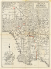
Scarce early map of the City of Los Angeles, drawn by E.F. Hill and published by Chadwick.
Chadwick's guide book was a successful publication in the 1920s and is useful for tracking the remarkable growth of Los Angeles between World War I and the Crash of 1929.
This is the time period when West Los Angeles was rapidly developed and annexed into the Los Angeles City limits.
The map is also noteworthy for its list of rail and transit lines, including:
- The Yellow Cars of the Los Angeles Railway
- The Red Cars of the Pacific Electric Railway
- Steam Railways
A list of 22 Yellow Car Routes is given.
On the verso is a map of Southern California, with inset maps showing the Inland and Coastal Coastal Routes of Southern California.
![[Official Route Map Los Angeles]](https://storage.googleapis.com/raremaps/img/small/70212.jpg)