


|
||

|

|
|

|
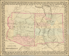
Highly detailed antique Wheeler survey regional map of southern Colorado and northern New Mexico covering the area west of the Rio Grande Gorge, as it passes from New Mexico to Colorado. Taos, New Mexico is just off the southeast corner of the map and is not covered.
The Wheeler survey charts were concerned with numerous aspects of the physical geography and how the West could be settled and exploited economically. The present map is one of the Economic Resource maps and shows the following four zones: Agricultural (with irrigation); Timber; Grazing; Arid and barren. Most of the land covered by the map is suitable for timber or grazing, according to this mapping.
Dozens of place names and elevations, along with remarkable topographical detail.
The Wheeler Survey
n 1866, Joseph S. Wilson, the Commissioner of the General Land Office, assessed the mineral resources of the US and opined the proper development was a matter of the highest concern to the American people. On March 2, 1867, Congress authorized the first western explorations in which geology would be the principal objective: a study of the geology and natural resources along the fortieth parallel route of the transcontinental railroad, under the Corps of Engineers, and a geological survey of the natural resources of the new State of Nebraska, under the direction of the General Land Office.
Four major surveys resulted, generally referred to by their leaders on the ground, King, Hayden, Powell and Wheeler. In 1869, Lieutenant George Wheeler was Engineer Officer on the staff of the Commanding General of the Army's Department of California (which covered California, Nevada, and Arizona). Wheeler, then only 26, had graduated sixth in his class from West Point in 1866.
In early June 1869, Lieutenant Wheeler was ordered to organize and equip a party to explore the country south and east of White Pine, Nevada, as far as the head of navigation on the Colorado, to obtain data for a military map and to survey the possibility of a wagon road and select sites for military posts. In 1871, the Engineers sent Lt. Wheeler to explore and map the area south of the Central Pacific Railroad in eastern Nevada and Arizona. On his return from the 1871 expedition, Wheeler, convinced that the day of the pathfinder had ended, proposed a plan for mapping the United States west of the 100th meridian on a scale of 8 miles to the inch, expected to cost $2.5 million and take 15 years. Congress authorized the program on June 10, 1872.
The present work was included in the U.S. Geological Surveys West of the 100th Meridian, as part of the Atlas to accompany the Expeditions of 1873, 1874 & 1876.
![(Colorado Photographs) [Collection of 22 Rocky Mountain Scenery cabinet cards, including views of Denver, Georgetown, railroads, mining relating scenes and more]](https://storage.googleapis.com/raremaps/img/small/93382.jpg)
![[ New Mexico - West Texas ] Estacaco Plain (406) World Aeronautical Chart](https://storage.googleapis.com/raremaps/img/small/96896.jpg)
![[Poster] IBM Advertising - Boulder, Colorado](https://storage.googleapis.com/raremaps/img/small/78793.jpg)