


|
||

|

|
|

|
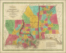
Early Map of the America's Southern States and Territories
Early American printed map of the Southern portion of the United States, extending from the Atlantic to the Mississippi and showing part of Kentucky.
Georgia is now truncated near its current border and a massive Mississippi Territory is present (pre-dating the creation of Alabama Territory), with a note that both Georgia and the United States claim this land. West and East Florida are still named. Tennessee is now a state, and Knoxville, Sullivan, Jonesboro, Greenville and Nashville all appear. Many Indian Tribes, Villages, forts and Court Houses are named.
This was one of the earliest regional maps of the South published in America and reflects the primitive state of the settlements west of the Appalachians. This updated edition is one of the earliest maps to name Mississippi Territory, which was created in 1798, with Georgia finally conceding its claims to the land in 1804. The configuration continued until Alabama became a Territory and Mississippi became a state in 1817.
States of the Map
This is the first state of the map. In 1804, the map would be revised to include Mississippi Territory.
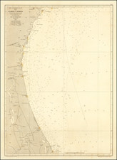
![[ Port Royal, South Carolina ]](https://storage.googleapis.com/raremaps/img/small/81298.jpg)

![[Hand Drawn Map] Le Golfe de Mexique avec les Pays Circonvoisins](https://storage.googleapis.com/raremaps/img/small/91580.jpg)