


|
||

|

|
|

|
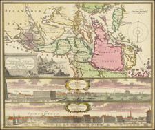
Very rare Swedish map of the region around Lakes Vättern and Vänern, covering the traditional Swedish provinces of Linkopings and Karaborgs, as well as parts of the neighboring provinces.
The attractive title cartouche includes allusions to water (and its bountiful nature), which is common with the Swedish maps of this time.
In the lower-right corner the map has the engraving credit: "Graverad af C: Bergquist och F. Akrel 1774."
Marelius is considered Sweden's foremost cartographer before the 19th century,
Nils Marelius first worked at the the Swedish Surveying and Mapping Office in 1734. He became an assistant surveyor in 1747 and later an engineer, working his way up to director in 1781.
Marelius authored and nd published a number of important maps and cartographic surveys.
Marelius became a member of the Academy of Sciences in 1769.
![[ Baltic Sea / Sweden / Poland / Rugen ] De Custen van Denemarcken en Sweden, van Valsterbon tot Schenkenes, als mede de cust vanten van Pomeren van't eylant Rugen tot Rygshooft . . .](https://storage.googleapis.com/raremaps/img/small/99944.jpg)
![[Denmark and southern Sweden]](https://storage.googleapis.com/raremaps/img/small/75156.jpg)