


|
||

|

|
|

|
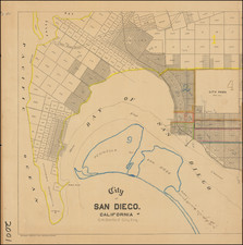
Large wall map of the San Diego neighborhoods of Point Loma, Mission Bay, Mission Beach, Pacific Beach, and Bay Park.
This is a very large and detailed wall map of these neighborhoods, depicting them at 1:400 feet.
One of the most interesting aspects of this map is the additions inside present-day Mission Bay (at its lower-right corner), which show large neighborhoods that were never built. The map depicts the Bay prior to the significant dredging and hydroengineering of the 1940s, which created almost all of the Mission Bay waterfront that one sees today.
The Sellore Addition, Electric Line Addition, and Mission Beach Addition are all either underwater or now part of Fiesta Island.
An outline for Shelter Island is shown off the coast of Point Loma.
![Map of the City of San Diego and Vicinity [cover title:] Street Map of San Diego](https://storage.googleapis.com/raremaps/img/small/77116.jpg)
![(San Diego Panoramic Photograph) U.S. Marine Barracks [Panoramic photograph of San Diego Marine Corps Recruiting Depot (MCRD)]](https://storage.googleapis.com/raremaps/img/small/99633.jpg)