|
||

|

|
|

|
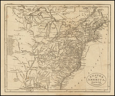
Unrecorded Early State With a Massive Pre-Republic Texas Configuration.
Rare map of the United States, with excellent detail of the post-Pike and -Lewis and Clark West and some short-lived territorial configurations.
This is an unrecorded, early state of William Darby's map of the United States without the large "Louisiana" in block letters across Louisiana Territory nor with the State of Louisiana labeled. Perhaps most interestingly, this first state shows Texas extending far to the north and west, across the Rio Grande River, a configuration that would be modified and reduced in the subsequent edition of the map.
In 1818, the more common state of the map was published in Darby's The Emigrant's Guide to the Western and Southwestern States and Territories... with "LOUISIANA" and "State of Louisiana" added to the map, Texas moved east of the Rio Grande, and hand-coloring delineating the states, Texas, and the Spanish Provinces. The map, and subsequently the guide, was created to encourage emigrants to travel west of the Mississippi River.
In this edition, the northern borders of Louisiana, which had become a state in 1812, are delineated with dashed lines, with the remaining borders marked by the Mississippi and Sabine Rivers, but the state is not yet labeled.
Texas is labeled with large letters, similar in stature to that of "Spanish Internal Provinces," although the borders of Texas remain ambiguous. In the 1818 edition of this map, Texas is delineated by color in an unusual, early "stovepipe" configuration with a narrow panhandle trailing northwesterly into the Rocky Mountain region, bounded by the Rio Grande in the west and the Red River in the north. In this early state, however, the "T" of "Texas" is positioned west of Rio Grande River, and the "E" is south of Santa Fe rather than east of the city.
A note located in the interior portion of Texas states that "this part of the Provincias Internas is but imperfectly known; no scientific traveler having ever explored, the wide range from St. Antonio de Behar to Red River."
The name "Northwest Territory" has also been added to the map.
To the east of Lake Timpanagos (Great Salt Lake), an entry reads: "Plains of the Mother of Light". This is a unique naming -- we find no other map or other reference in print using this title, which we assume is a translation from Spanish or French, but the translation "Llanuras de la madre de la luz" does not yield any results.
Missouri Territory is named, but not delineated, and appears confined along the western bank of the Mississippi River taking up modern-day Missouri and Arkansas. The inclusion of Alabama Territory dates the map to no earlier than 1817.
The map locates "Pompey's Pillar" William Clark's having climbed a sandstone pillar and "had a most extensive view in every direction on the Northerly Side of the [Yellowstone] river". He named the outcropping after Jean Baptiste Charbonneau, the son of expedition member Sacagawea, whom he nicknamed "Pompy". His original name for it was "Pompys Tower"; but the name was changed to the current title in 1814.
There are numerous spurious mountain ranges stretching throughout the United States, and the locations of a number of Native American Indian tribes are also noted. Engraved by James D. Stout and printed by Harrison & Bushworth. The second state of the map identifies Harrison & Bushworth as printers in Brooklyn. While we have not done a comprehensive study of Brooklyn printers and engravers, this is certainly one of the earliest maps to include be printed in Brooklyn.
As noted below, this is one of only few maps engraved by James D. Stout, who would go on to a successful career as a silversmith.
Rarity
This is the only example of this state of the map that we have been able to locate.
We note that Darby's Emigrant's Guide is relatively scarce and that the map is also frequently lacking from the book.
James D. Stout was a silversmith, engraver and seal-sinker in New York City, active from about 1810 to 1835.
Born in Middletown, New Jersey on October 5, 1786. Working primarily as a silversmith and engraver.
His earliest map printing work would seem to be the Prior & Dunning edition of David William Smyth's Map of Upper Canada . . . , published in 1813.
He is also credited with a the engraver of Jacob Willets map of the State of New York in 1815.
William Dunlap's History of the Rise and Progress of the Arts of Design in the State of New York in the ..., Volume 3, lists Stout as a map engraver, in about 1813.