|
||

|

|
|

|
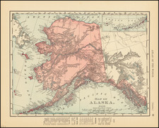
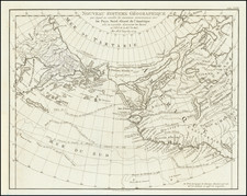
Very detailed map of Alaska, shortly after the start of the 1897 Gold Rush.
The map shows Indian Villages, towns, rivers, mountains, forts and other details. Senatis Village, Charley's Village, Attenmut Village, and other early Indian settlements are noted.
The use of indigenous names is noteworthy.
The coal veins of Cape Beaufort are also shown. First discovered by Nathaniel Portlock in 1786 and mined as early as 1855 by the Russian-American Company.
George F. Cram (1842-1928), or George Franklin Cram, was an American mapmaker and businessman. During the Civil War, Cram served under General William Tecumseh Sherman and participated in his March to the Sea. His letters of that time are now important sources for historians of the Civil War. In 1867, Cram and his uncle, Rufus Blanchard, began the company known by their names in Evanston, Illinois.
Two years later, Cram became sole proprietor and the company was henceforth known as George F. Cram Co. Specializing in atlases, Cram was one of the first American companies to publish a world atlas. One of their most famous products was the Unrivaled Atlas of the World, in print from the 1880s to the 1950s.
Cram died in 1928, seven years after he had merged the business with that of a customer, E.A. Peterson. The new company still bore Cram’s name. Four years later, the Cram Company began to make globes, a branch of the business that would continue until 2012, when the company ceased to operate. For the final several decades of the company’s existence it was controlled by the Douthit family, who sold it just before the company was shuttered.