This item has been sold, but you can enter your email address to be notified if another example becomes available.


|
||

|

|
|

|
Stock# 68518op
Description
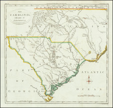
One of the Earliest Obtainable Maps of Charleston
Detailed map of the area around Charleston, from Bellin's La Petit Atlas Maritime.
Shows the Ashley River, Charleston (including the fortifications designed by De Brahm), Fort Johnson, the Cooper River and other details.
One of the earliest obtainable maps of Charleston.
![[ Carolinas & Georgia ] Carte De La Caroline Et Georgie . . .](https://storage.googleapis.com/raremaps/img/small/99744.jpg)
![[Defending The Southern Coast During the Spanish American War] Map of Sea Islands, Coast of Georgia. from St. Mary's River to Savannah River compiled from the best Authorities 1864 / Map of Sea Islands. Coast of Georgia. from St. Mary's River to Savannah River compiled from the best Authorities 1864 /](https://storage.googleapis.com/raremaps/img/small/59563.jpg)