|
||

|

|
|

|
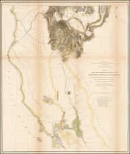
A Search For The Best Routes To The West. "[O]ne of the most interesting maps of the West" - Wheat 868
This is a scarce map which accompanied the Report of Capt. R. Ingalls on the March of L. Col. Steptoe from Ft. Leavenworth to California, in 1854 and 1855. The map shows the routes taken by several parties and expeditions as they searched for an optimal route from Salt Lake City to the California coast. The map presents the details of these routes, including mountains, rivers, lakes, towns, and forts, and is of particular note regarding Mormon settlements in California.
Wheat calls this uncommon map of the Great Basin "one of the most interesting maps of the West" and "a document of first quality, showing, as it does so well, three important routes" from Salt Lake City to California.
Detail is extensive on this map, showing all the topography that was known at the time. The Sierra Nevada are marked as an imposing mountain range, separating California from the east. The north/south-oriented chains of the Basin and Range are marked carefully, with topographic detail extending to the Wasatch range. The "Columbia" [Snake] River can be seen just north of Utah and the Great Salt Lake. Early cities marked throughout California include San Diego, Los Angeles, Santa Barbara, San Jose, and San Francisco. Mining towns are marked at the western foot of the Sierra, some of them unmarked.
The tale behind the map is as follows. Three army detachments set out in 1855 with the intention of finding shorter and less rugged routes for emigrants and mail carriers heading to the west coast. One group, led by Colonel E. J. Steptoe, followed the Humboldt and Carson Rivers and then crossed the Sierra to Sacramento and Benicia. A second, led by Captain Rufus Ingalls, took the usual route to the Great Salt Lake and down the Humboldt, but then bore northwest into southern Oregon and finally south to Sacramento. The third group, under the command of Lieutenant Sylvester Mowry, went south past the Mormon settlements of Provo and Nephi, came near the site of the Gunnison massacre, and arrived at Las Vegas, which at the time was a small Mormon Indian mission. From there, Mowry crossed the desert, skirted north of the San Gabriel mountains, and eventually reached Ft. Tejon via Cajon Pass, a tiny Los Angeles, and Tejon Pass.
Despite the successful routes found and cutoffs proposed, none of these trails became particularly popular. The California Gold Rush had passed its peak, with emigration decreasing rapidly after 1855. Further, the completion of the Panama Railroad made ship travel a significantly more appealing option.
![[ San Francisco Bay, North Coast & Monterey Bay Region ] Amer. Sep. No. 46 Nouvelle Californie](https://storage.googleapis.com/raremaps/img/small/98751.jpg)
![[ Chinese Voyages To America, etc. ] Memoires De Litterature, Tires Des Registres De L'Academie Royale Des Inscriptions et Belles-Lettres Depuis l' annee M. DCC. XVIII. julques & compris l'annee M. DCC. XXV Tome Quarante-Neuvieme](https://storage.googleapis.com/raremaps/img/small/101296.jpg)