


|
||

|

|
|

|
Final Hand-Corrected Proof State?
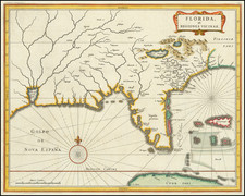
Hand annotated example of this rare Adelsverein map of a part of central Texas, which was then being settled by Texas immigrants under the auspices of the Verein zum Schutze Deutscher Einwanderer Nach Texas (Society for the Protection of German Emigrants to Texas).
This rare map is important for a number of reasons, perhaps the most notable of which is that it reflects the survey work of the Adelsverein engineers, based in New Braunfels. The map shows the area between the fork of the Concho and Colorado Rivers in the northwest to New Braunfels and San Antonio in the southeast. The roads shown include the route taken by John O. Meusebach's party (including the mapmaker, Hermann Willke) to the San Saba in 1847, on the occasion of the signing of the Comanche Peace Treaty which allowed for the "peaceful" settlement of the region by the Verein.
The map is also noteworthy for its identification of a number of early Land Districts from the Fisher-Miller Grant, pre-dating the Verein's acquisition of the land, including the unnumbered New Brauenfels and Friedrichsburg Districts and numbers districts, naming Howard, Bingham, Tivy (2), Montel, Hudson, Giddings, Erskine, Hay and Harwey.
The map is the work of Texas pioneer Hermann Willke, one of the most important early Texas Surveyors, who was responsible for mapping much of the Verein land grants and towns and later was one of the first surveyors employed by the Texas Land Office. Included in this unique example are manuscript annotations which would later become a part of the final printed version of the map, leading to the conclusion that the annotations are quite possible in the hand of either Hermann Willke, or Ludwig Bene, who traveled to Germany in 1850 and may have had a roll in the preparation of the map for final printing in Germany.
The map shows early land grants in Texas and German settlements in the Fredericksburg and New Braunfels areas. As noted below, the present example is an early or proof state of the map. The final version of the map appeared in Instruction fuhr deutsche Auswanderer nach Texas, an instructional guide prepared by the Society for new immigrants to the region.
Proof States of The Map
The present example is apparently the final proof state of the map, prior to its publication. In 2013, we offered an earlier proof state, with pencil annotations which are now incorporated in the present proof state. https://www.raremaps.com/gallery/detail/32972
The present example corrects numerical errors in the prior proof state (in red pen) and adds the following passage below the corrections:
der vermessene und kartirte Theil des Grantgebietes ersteckte sich uber eine Flache von circa 160 deutschen oder 4000 englischen quadratmeilen.
Translation: The measured and checked part of the border area extended over an area of about 160 German or 4,000 English square miles.
The final published edition of the map incorporates these changes, with only minor punctuation corrections. https://texashistory.unt.edu/ark:/67531/metapth192564/m1/1/zoom/?resolution=1&lat=7354.053134492209&lon=5534.118493345024
Publication of th Map
The maker, "H. Willke" is Hermann Willke, who along with his brother Ludwig Willke, had been a Lieutenant in the 30th Regiment of the Prussian Army (Berlin) before coming to Texas. Born in Collberg on the Baltic Sea, the Willke Brothers came to Texas aboard the Brig Ferdinand, arriving in Galveston in December, 1844.
Hermann Willke first served as the Verein's assistant surveyor with an annual salary of $100, serving under Nicolaus Zink in the original survey of the New Braunfels. He also served under John O. Meusebach as the surveyor for lots in Fredicksburg. In 1847, Hermann Willke was one of the "five educated young Germans" who accompanied Meusebach into the Verein's grant for the Comanche Peace Treaty. Later in 1847, Hermann Willke was named surveyor of the grant. As noted in Everett Fey's The First Founder Biographies:
At the end of that year, Willke was named surveyor of the grant. He was to transport supplies into the grant by mule team, so he and his brother bought ten mules in New Braunfels. Willke took up residence in the grant, surveying and painstakingly mapping it to facilitate its distribution to the German immigrants. He served the Emigration Society successively under Prince Solms, Meusebach, H. Spies and Lieutenant Ludwig Bene. During his more than eight years of work for the Verein, correspondence in the Society's archives about and with Willke reached considerable volume.
As noted in Pioneers in God's Hills:
With Bene, Willke worked as fellow surveyor. Before Bene traveled to Europe in 1850 to appear before the Verein, he recommended that H. Willke, a worthy, honorable and responsible man, be appointed the Verein's Agent-General in Texas. Willke, Bene avowed, was not only indispensable as surveyor, but could well carry on both posts. This Willke did satisfactorily. His neat and accurate maps of Indianola, New Braunfels, Fredericksburg, the land grant and other places, also became graphic links between the Verein officials in Wiesbaden and Texas.
[Because of dwindling funding]. . . Bene wrote the Verein in 1852 that he and Willke were having to live on their own resources. On February 1, 1853, town lots and out lots at Fredericksburg, having been recorded in the court, the surveying in the grant having been completed so that the land awaited only state legislation before it would be distributed to the colonists, Herman Willke resigned as Verein surveyor. He was to be employed by the Texas General Land Office in Austin at the salary of $1000.00 a year.
Rarity
The map is of the utmost rarity. We note no examples of the separate map appearing at auction. The pamphlet was last offered by C.D. David in 1964 for $1,000.


![(Texas Revolution) [Manifesto on the Texas Campaign, issued by General Filisola in justification of his conduct, Gen. Santa Anna's correspondence with Vicente Filisola after capture at Battle of San Jacinto, and other documents] Mejicanos [caption title].](https://storage.googleapis.com/raremaps/img/small/94669.jpg)