


|
||

|

|
|

|
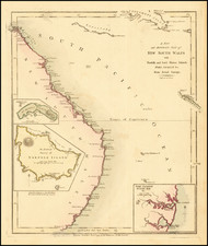
One of the First Maps of Wellington, New Zealand
Fine example of one of the first printed maps of the area which would become Wellington, New Zealand, published in 1843. It was published for the New Zealand Company, one of the early, and controversial, entities dedicated to the settlement of New Zealand by British colonists.
The land is portioned into “country sections” of 100 acres each. These would be advertised and sold to prospective landlords in England, who were then supposed to immigrate to be New Zealand’s new landed gentry. The Company would pay for laborers to immigrate to work the land. In practice, however, the landlords tended to stay in England, while the laborers came in great numbers, creating an uneven system.
The country sections here are color coded: government reserves are pink, public reserves are green, and native reserves are yellow. The latter of these were supposed to be ten percent of the overall land plots. These were to be interspersed among the other types of sections; it was thought, paternalistically and imperialistically, that exposure to Western culture would “civilize” the Maori.
Above the title is the Company’s coat of arms, with a British man and a Maori man flanking the symbolic arms. The engraver is B. R. Davies, but the publisher is Smith, Elder, and Co. of Cornhill. They published all the books, maps, and pamphlets of the New Zealand Company, which were printed at a rapid rate in the early 1840s.
The New Zealand Company in Te Whanganui-a-tara (Wellington Harbor)
The map includes obstructions offshore and local geographic features. There are rivers and hills, but otherwise the map shows a deceptively simple, and suggestively ordered and empty, terrain. The native reserves imply that the local Maori were already confined to those spaces, and that the area was ready for settlement. In reality, settlement was confined to the small developed section at Lambton Harbour. Additionally, the entire claim of the New Zealand Company in the Port Nicholson/Wellington area was under dispute when this map was published.
The New Zealand Company arrived in the area in 1839, with a survey party and translators in the Tory to negotiate with local chiefs. They made many quick deals with Maori to “sell” land to the Company; soon, Company officials estimated that they held the title to 20,000,000 acres. By the end of 1840, they had also sent hundreds of settlers to Port Nicholson.
However, under the direction of Lieutenant-Governor William Hobson, all land claims made before early 1840 were to be reviewed. Officials were worried about dispossession of the Maori and rampant speculation. A New Zealand Land Commission began to review claims around the Bay of Islands in early 1841. For the New Zealand Company claims near the Cook Strait, a separate commission was created, headed by attorney William Spain.
Although initially confident that their claims would be upheld, this confidence proved to be misplaced after hearings began in mid-May 1842. In order to secure their title, the Company offered a compensation scheme. Negotiations over payment dragged into 1843, when this sketch was distributed.
After the Wairu Incident, when six Maori and 22 Europeans were killed, the situation became dire. Governor Robert Fitzroy, who forced the compensation to be paid, even though several Maori leaders still objected for various reasons. By April 1844, the town site and most of the Port Nicholson titles were settled, but this had not stopped the New Zealand Company from advertising the sections during the process, as this map shows.
Rarity
The map is quite rare. OCLC locates two examples: the Alexander Turnbull Library (National Library of New Zealand) has four copies and the General Library of the University of Auckland has a copy. The British Library also holds an example in their collections.
The New Zealand Company and early British settlement
The New Zealand Company was established in 1839 to colonize New Zealand. They were not the only such company, but they were the most prominent. For example, the New Plymouth Company, established in 1840 to settle a peninsula on the North Island, merged with the New Zealand Company in April 1841.
The roots of the company go back further. The British first settled permanently on New Zealand when missionary activity began there under the auspices of the Church Missionary Society. Samuel Marsden, William Hall, Thomas Kendall, and John King were the first missionaries; Marsden gave the first sermon in New Zealand on Christmas Day 1814.
By 1831, there were enough European settlers to cause considerable consternation on the part of the Maori leaders. Thirteen Northern chiefs petitioned King William IV for protection, which the Crown granted. Two years later, the British Resident, a consular position, arrived and built a house in Waitangi. In 1835, the Resident, James Busby, drafted He Wakaputanga o te Rangatiratanga o Nu Tirene, the Declaration of Independence of New Zealand, which placed the sovereign power of the land with the Maori and their hereditary chiefs. By 1839, 52 chiefs had signed the declaration.
In the meantime, the British, who had not sanctioned the declaration, decided to begin formally colonizing New Zealand in 1837. This is the same year discussions began to form the New Zealand Company from a previous venture, the New Zealand Association, which had failed to gain a royal charter. The British government appointed William Hobson to serve as Consul, under the authority of the Governor of New South Wales. Hobson was to oversee the purchase of land from the Maori.
By 1840, there were roughly 2,000 Europeans living in New Zealand, the majority single men—whalers, traders, and missionaries—and 7 of 10 of them were of British descent. They usually arrived via Sydney, in New South Wales.
At the same time the government was appointing a Consul, the first New Zealand Company ship had set sail for the islands. The Company's ship, the Tory was to survey and buy land for a settlement, which was decided to be at Port Nicholson (now Wellington Harbor). The first settlers arrived in Port Nicholson in January 1840, having been attracted as laborers by exaggerated pamphlets and propaganda published by the Company.
The Treaty of Waitangi and the downfall of the New Zealand Company
The New Zealand Company was based on the idea that only civilized (white) men should own land; they sold land in “country sections” at “suitable prices” to investors. Then, the Company shipped over laborers to ensure there was a labor pool to work the land. However, many of the owners never emigrated, making them absentee landlords. Additionally, many of the purchases of land from the Maori were dubious at best.
Ironically, just as the initial settlers in Port Nicholson and the Company’s others early settlements—Whanganui (September 1840), New Plymouth (November 1841), and Nelson (February 1842)—were realizing that New Zealand was not the paradise they had been promised and that the land had not been fairly purchased, news of the New Zealand Company’s royal charter, granted in 1841, reached the islands. This was not enough to quell the discontent of the settlers and debate swirled in London as to the reputation of the Company.
In New Zealand, 1840 also marked the signing of the Treaty of Waitangi. The New Zealand Company was not the only body engaged in dubious land deals with the Maori. Governor Gipps of New South Wales prohibited further land sales early in the year, calling for all existing purchases to be reviewed. On February 6, 1840, the Treaty of Waitangi was signed by roughly forty chiefs; by September five hundred more signed on. A draft of the treaty had been read in Maori the day before, but the degree to which it contents were fairly translated and understood before being signed is a matter of controversy to this day.
The Treaty ceded the lands of New Zealand to British control and codified the systematic territorial and material dispossession of the Maori. One of the reasons for this move by the Crown was to counter New Zealand Company attempts to declare sovereignty over the Cook Strait, which was south of the main British strongholds on the North Island.
The New Zealand Company continued to sell land after the Treaty, on the North and the South Islands. This often led to conflict; New Zealand Company settlers clashed with the Maori over a shady land deal in the Wairu Incident of 1843; six Maori and 22 Europeans were killed. The fortunes of the New Zealand Company continued to decline and the company surrendered its charter in 1850; it officially dissolved in 1858.
Despite its short-lived and controversial history, the New Zealand Company was responsible for bringing 14,000 of the 18,000 people who settled in New Zealand between 1840 and 1851. Their promotional practices were used to continue to draw European settlers to the islands even after the company folded.
![[ New Zealand ] Carte De La Nle. Zelande visitee en 1769 et 1770 par le Lieutenant J. Cook Commandant De L'Endeavor Vaisseau de la Majeste](https://storage.googleapis.com/raremaps/img/small/99726.jpg)
![[ New Zealand ] Partie De La Nle. Zelande. Oceanique No. 59 [with] Partie De La Nle. Zelande. Oceanique No. 60](https://storage.googleapis.com/raremaps/img/small/74654.jpg)
![A Chart of the South Sea [1st English Map of the Pacific Ocean]](https://storage.googleapis.com/raremaps/img/small/47376.jpg)
![Isles de Salomon [Early depiction of New Zealand!]](https://storage.googleapis.com/raremaps/img/small/101683.jpg)