|
||

|

|
|

|
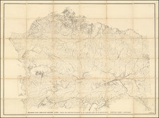
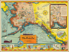
Rare Military Air Map for Alaska
Rare oversized aeronautical map of Alaska, published by the United States Army Air Corps, Information Division.
The map was issued very early in the Aeronautical history of Alaska. The first manned flight in Alaska took place in 1913, with the first commercial air service in 1927. The map pre-dates the boom in the early 1940s, when the US Military established a number of air bases during World War II, under the auspices of the Alaska Air Command.
The map was prepared in order to allow military pilots to fly between Fairbanks and the Anchorage / Seward area using visual flight rules and a compass.
The base map utilizes topographical symbols to shown mountains, rivers railroad tracks, towns, mines/quarries and roads. Compass variations are also shown.
The map also locates:
- Military Airfields
- Commercial and Municipal Air Fields
- Department of Commerce Intermediate Fields
- Marked Auxiliary Fields
- Sea Plane Bases
- Anchorage
- Emergency Sea Plane Anchorage
Rarity
OCLC locates 2 copies: University of Wisconsin, Milwaukee (American Geographical Society) and University of Chicago.