|
||

|

|
|

|
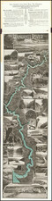
This is a detailed navigational chart of Otago Harbor, on New Zealand's South Island. The map extends inland along the winding channel of the harbor to Dunedin, with the layout of the city visible. Navigational detail on the map is extensive, and it shows many soundings, shoals, channels, banks, and much more. Two inset maps show the entrance to the harbor and Port Chalmers in even greater detail, with many additional soundings and notes. Three depictions of the harbor are shown from various angles so as to better help with navigation.
Otago Harbor is a natural deepwater port that has been of prime importance to the economy and livelihood of southernmost New Zealand since the 18th century. Despite not being explored by Cook, sealers were likely already using the port by the 1770s. The Sealers' War of the early 1820s commenced after the theft of a shirt and knife by a Maori native from a sealer vessel that had stopped in the bay. The growth of Dunedin before and during the gold rush led to further use of the harbor, and for a time the city was one of the most important in New Zealand. Improvements to the harbor ensued and can be seen on the map.
As with all British Admiralty charts, this map provides a wealth of information while preserving a simple and attractive design.
![New Zealand [w/inset of Van Dieman's Land]](https://storage.googleapis.com/raremaps/img/small/96555.jpg)
![Isles de Salomon [Early depiction of New Zealand!]](https://storage.googleapis.com/raremaps/img/small/101683.jpg)