|
||

|

|
|

|
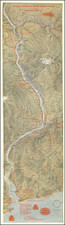
Attractive vintage pictorial map of the Pacific Northwest showing the routes operated by West Coast Airlines through the region. Fifty-two points of interest are depicted and described in an index. A large Paul Bunyan stands in the foreground of the map, while the verso includes twelve pictures of the sights of the region.
The map is attractively and tastefully designed. The imagery used shows the industries, attractions, and landmarks of the region, and these are well detailed, with many interesting factoids included. The routes shown on the map link many small cities towns and resorts of the area, allowing for greater economic development in the region.
West Coast Airlines existed from 1941 until it was merged to form Air West in 1968. It was supposedly the first airline to be granted a regional certificate by the CAB (precursor to the FAA). The airline served regions all over the west coast, with its hub in Seattle. A promotional campaign by the airlines featured several other Paul Bunyan themed ads, painting a rough and rural picture of the Pacific Northwest for prospective tourists.