|
||

|

|
|

|
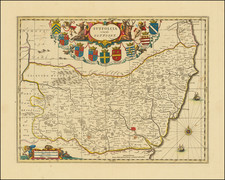
A detailed county map of Rutland prepared by Robert Morden in 1695 and most likely printed as part of the 1722 edition of Camden's Britannia. The map of this small county is attractively designed, with forests, lakes, and towns all shown, and larger cities depicted pictorially. The map includes two cartouches and a decorative compass rose.
The map shows the historical county of Rutland, subdivided according to its hundreds. This tiny county, only eighteen by seventeen miles, is the smallest historical county of Britain. The prominent cities of "Okeham" and Uppingham are shown in intriguing detail. While Rutland Water is not visible on the map, which was created with the damming of the Gwash in 1975. Burley is shown on its eponymous hill.
Parts of the adjacent counties of Leicester, Lincolnshire, and Northamptonshire are all shown. In all, this is an attractive and well designed Morden county map.
The map and atlas were sold by the partners A. Swale and A. Churchil.
William Camden, a schoolmaster, started on his Britannia 1577 at the encouragement of Abraham Ortelius. His first edition would be published in 1586, in a relatively modest and unillustrated first edition. One of the main focus points in the creation of the work was to present a classical study of Britain, with a definitive study on the island during Roman times. While scholars of the day were impressed by the work, the public was drawn in by the almost explicit critiques that Camden's historical narrative made against another chronicler, the famous tenth-century Geoffrey of Monmouth. Camden effectively rewrote history as it was accepted in Britain with his first work.
Five further editions of the text would be published in Latin, and one in English, during Camden's lifetime. Each edition expanded on the previous one, and the original five-hundred-and-fifty page work ballooned rapidly. The work would be reprinted in posthumous editions until at least 1789, and proposals for even later editions appeared into the twentieth century. Robert Morden illustrated a 1695 example, which was perhaps the most well known. Blaeu used portions of Camden's work in his 1645 Theatrum Orbis Terrarum as did Jansson in his 1646 Novus Atlas.
Robert Morden (d. 1703) was a British map and globe maker. Little is known about his early life, although he was most likely apprenticed to Joseph Moxon. By 1671, Morden was working from the sign of the Atlas on Cornhill, the same address out of which Moxon had previously worked. Most famous for his English county maps, his geography texts, and his wall maps, Morden entered into many partnerships during his career, usually to finance larger publishing projects.
![[Western England and Wales] Le provincie che sono all'ovest dell'Inghilterra e quelle del principato di Galles](https://storage.googleapis.com/raremaps/img/small/82448.jpg)