|
||

|

|
|

|
Stock# 82448
Description
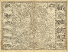
Detailed map of western England and Wales, with the flag of the Lord High Admiral on the right.
In England, Chestershire, Shropshire, Staffordshire, Warwickshire, Worcestershire, Herefordshire, and Gloucestershire are pictured. In Wales, all thirteen counties are depicted: Flintshire, Anglesey, Carnarvonshire, Denbighshire, Merionethshire, Montgomeryshire, Cardiganshire, Radnorshire, Brecknockshire, Pembrokeshire, Carmarthenshire, Monmouthshire, and Glamorganshire, although only twelve are listed to the right, missing Monmouthshire.
From Marmocchi's Atlante di geografia universale.
Condition Description
Original hand-color. Binding tab at top margin, with small nick near it on left margin.

![[Eastern England] Le Province de formano la parte dell'Est dell Inghilterra](https://storage.googleapis.com/raremaps/img/small/82228.jpg)