|
||

|

|
|

|
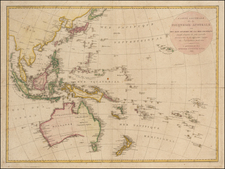
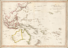
Striking Map of Australia Showing Mitchell’s First Three Important Exploratory Expeditions
Fine map of southeast Australia highlighting the routes of Thomas Livingstone Mitchell in his early expeditions to better survey inland Australia. His three expeditions provided many new maps and opened settlement in Australia Felix.
The map shows the coast from Port Macquarie in the east to Kangaroo Island in the west. The known region of New South Wales is demarcated, an area that Mitchell had already mapped as referenced by the title block to the left.
Mitchell’s routes are outlined, stretching to the north, northwest, and southwest. Near the routes, Mitchell has noted mountain ranges, rivers, and creeks.
He was also speaking with local Aboriginal peoples. On his northern track, for example, is the note, “Hereabouts according to the natives, the Nammoy spreads it’s [sic.] waters, or ‘dies’ on very extensive plains.”
In the bottom right corner are cross-sections of the many rivers surveyed by Mitchell. They show the banks and depth of the water. Near the edge of the map are profile views of islands in the Bass Strait. An inset in the lower left shows the mouth of the Glenelg, part of Mitchell’s third expedition.
Thomas Livingstone Mitchell and his explorations
Mitchell (1792-1855) was a gifted surveyor. He was born in Scotland and joined the British Army as a second lieutenant, serving in the Peninsular War. There, he worked with the topographical intelligence staff. He caught the eye of George Murray, quartermaster-general, who asked Mitchell to make plans of Peninsular War battlefields.
After the war, with Murray’s support, he was named assistant surveyor-general of New South Wales. He arrived in Sydney with his family in 1827. Mitchell set to work revamping the Survey Department, which was in disarray. In 1828 he became surveyor-general and in 1829 took sole responsibility for the entire Survey Department, abolishing the commissioners. He made significant improvements to the roads of New South Wales, as well as began a general survey, but he also clashed with other colonial officials.
In 1831, Mitchell led his first expedition. He wanted to verify a rumor he had heard that there was a large river flowing northwest. He focused on the area between the Castlereagh and Gwydir Rivers. He charted many of the tributaries of the Gwydir, but did not find his elusive river. In February 1832, Aboriginals killed two of his party and sacked his supplies, forcing Mitchell to return to Sydney.
In early 1835, Mitchell set out again, this time to trace the River Darling, hoping to build on the earlier exploration of Charles Sturt. He made his way northwest. Along the way, Richard Cunningham, the naturalist, wandered away from the group and was lost; you can see this on this map where it says “Mr Cunningham killed hereabouts.” Searches were in vain and later it was learned the Cunningham had been killed by local peoples. Mitchell reached a junction with the River Darling and followed it southwest. At the farthest point of this expedition, Mitchell clashed with Aboriginal peoples and returned the way he came.
Unsatisfied with the results of the first two expeditions, Mitchell was determined to explore further. His orders asked him to follow the route of the Darling to the sea or the Murray River, following it back to the inhabited parts of the colony. He left in March 1836, setting out for Boree. He struck out southwest and soon met the same Aboriginal peoples he had previously fought with on the Darling. He set an ambush for them, which was easily discovered, and fighting broke out; seven Aboriginal peoples died.
By late May, Mitchell’s party had reached the Darling. Once there, Mitchell abandoned his orders and instead surveyed the promising land near the Murray. This led him to the junction with the Loddon and rich, fertile land in what is today Victoria. Mitchell called this land Australia Felix. He reached the mouth of the Glenelg (inset) on August 20 and encountered the Henty brothers at Portland. He then turned back to the Murray and to Sydney.
After these three expeditions, Mitchell took leave in England. He wrote his account, with which this map was published, entitled Three Expeditions Into the Interior of Eastern Australia (1838). He also finished the battle plans of the Peninsular War which were published in 1840 by James Wyld. After some disagreements about debts, he returned to Australia in 1841.
In 1845, he began a fourth expedition. He again traveled to Boree and hoped to find an overland route to Port Essington. He surveyed along the Maranoa, Warrego, Belyando, and Barcoo Rivers. He thought he had found his large river at last, but this was not to be, even though he suggested as much in his account, Journal of an Expedition into the Interior of Tropical Australia (1848).
Later, he published The Australian Geography (1850, second edition in 1851). In his final years, Mitchell fought one of the final duels in Australia, published a paper and successfully trialed ideas on the application of a boomerang to ships’ propellers. For a third time while on leave in England he was threatened with dismissal for not returning to Australia. He did return in January 1854. Facing a Royal Commission that was investigating the Survey Department and Mitchell’s long history of insubordination, Mitchell caught a chill while surveying. He died of pneumonia on October 5, 1855.
While a poor administrator and difficult colleague, Mitchell was an accomplished explorer and a highly-skilled surveyor.
Thomas Livingstone Mitchell was a surveyor and administrator in the early years of the Australian colony. Mitchell received his training in surveying while serving in the British Army in the Peninsular War. In the late 1820s, Mitchell sought opportunity in Australia, where he served as assistant and then surveyor-general of New South Wales. He led four expeditions into the interior of Australia in the 1830s and 1840s, publishing two successful voyage accounts. He was also a politician and inventor of a boomerang-style ship’s propeller.

![[Melbourne, Australia] We show you Melbourne City, but from a dizzy height. Come see it as we know it, you'll vote it very bright!](https://storage.googleapis.com/raremaps/img/small/94298.jpg)