
![[Amsterdam] Amstelredamum, Nobile Inferioris Germaniae Oppidum By Georg Braun & Frans Hogenberg](https://storage.googleapis.com/raremaps/img/small/96920.jpg)


|
||

|

|
|

|
Exceptional Original Hand-Coloring.
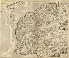
Finely colored example of Braun & Hogenberg's first view of Amsterdam, from Part I of their Civitates Orbis Terrarum, first published in Cologne in 1572.
Braun & Hogenberg's view is based upon a plan of Amsterdam by Cornelis Antoniszoon (1544), showing Amsterdam with its medieval walls and formal defensive systems. The view illustrates the unique Dutch form of urban plan with the Amstel River dammed near its mouth and its flow controlled by channels to the sea with an outer harbor created from the downstream portion, and an inner harbor from the upstream portion. The dam, located at the center, also provided the central plaza for public buildings. Numerous ships and fishing boats fill the harbors, attesting to the increased trade and commerce that Amsterdam was beginning to experience when this plan was published.
Cornelis Anthoniszoon (1505 to 1553) was a grandchild of Jacob Cornelisz van Oostsanen, who probably taught him to paint, and a cousin of Dirck Jacobsz. In 1538, Anthoinszoon painted the first complete map of Amsterdam as a commission from the city fathers, to present as a gift to Charles V. Anthoniszoon. He is best known for his woodcuts, especially his view of Amsterdam, from 1544. This was printed in 12 blocks of wood and was re-issued until well into the 17th century.
The cartouche text translates as follows:
Amsterdam is a well-known city in Lower Germany that has arisen in recent times to accommodate merchants and is inhabited by people engaged in trade. It is almost impossible to think of a commercial activity that is not practiced here. Hence profit-seeking businessmen are drawn to this city from the most far-away lands and tranship various goods, first and foremost grain, to Brabant and other parts of the world. Vast riches result from trade of this kind.
Braun's commentary on the verso translates as follows:
Holland is the most fertile part of the Netherlands. It is crossed by many waterways full of fish, which ensure that in the whole world there is no other landscape in which so many cities lie within such a confined area ... Amongst these, Amsterdam is the noblest ... It lies on the River Amstel, from which many canals lead into the city. About twice a year many ships arrive here from all over Europe, some 200 or 300 from the Netherlands, France, England, Spain, Portugal, Germany, Poland, Lithuania, Norway, Sweden and the other countries of the North. ... There are also very good and experienced ship-builders here. ... This city is supported on large and sturdy wooden stilts that have been driven into the bed of the water. When you see the air, the sea, the dams and the many sluices, you can easily compare the city with Venice and consider it just as fortunate.
Georg Braun (1541-1622) was born and died in Cologne. His primary vocation was as Catholic cleric; he spent thirty-seven years as canon and dean at the church St. Maria ad Gradus, in Cologne. Braun was the chief editor of the Civitates orbis terrarum, the greatest book of town views ever published. His job entailed hiring artists, acquiring source material for the maps and views, and writing the text. In this role, he was assisted by Abraham Ortelius. Braun lived into his 80s, and he was the only member of the original team to witness the publication of the sixth volume in 1617.
Frans Hogenberg (ca. 1540-ca. 1590) was a Flemish and German engraver and mapmaker who also painted. He was born in Mechelen, south of Antwerp, the son of wood engraver and etcher Nicolas Hogenberg. Together with his father, brother (Remigius), uncle, and cousins, Frans was one member of a prominent artistic family in the Netherlands.
During the 1550s, Frans worked in Antwerp with the famous mapmaker Abraham Ortelius. There, he engraved the maps for Ortelius’ groundbreaking first atlas, published in Antwerp in 1570, along with Johannes van Deotecum and Ambrosius and Ferdinand Arsenius. It is suspected he engraved the title page as well. Later, Ortelius supported Hogenberg with information for a different project, the Civitates orbis terrarium (edited by Georg Braun, engraved by Hogenberg, published in six volumes, Cologne, 1572-1617). Hogenberg engraved the majority of the work’s 546 prospects and views.
It is possible that Frans spent some time in England while fleeing from religious persecution, but he was living and working in Cologne by 1580. That is the city where he died around 1590. In addition to his maps, he is known for his historical allegories and portraits. His brother, Remigius, also went on to some fame as an engraver, and he died around the same time as his brother.

![[Delft]. Delphium urbs Hollandiae cultissima, ab eiusdem nominis fossa vulgo, Deelft appellata](https://storage.googleapis.com/raremaps/img/small/54931mp2.jpg)