


|
||

|

|
|

|
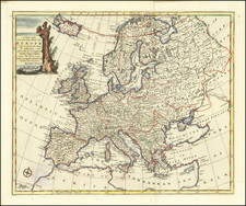
Antique 18th-century map of Europe. The sixteen states within Europe are colored, while North Africa and the Middle East are left unfilled. Abundant detail on settlements and geomorphologies throughout Europe and abroad. The map is framed by crests from the various cities, provinces, and states of Europe.
The region surrounding Crimea is labeled as part of "Petite Tartarie." Sweden and Poland control vast swaths of northern Europe. The Holy Roman Empire is extensive throughout Eastern Europe, though France extends into Alsace-Lorraine and Switzerland.
The Prime Meridian is interestingly shifted approximately fifteen degrees west of its present location. This is following the location chosen by de Fer, at the order of the king. The note at the bottom left describes in French how Danet projected the map. The cartouche uses picturesque imagery of European culture and power.
The map was first issued by Danet in 1731 and later revised by Desnos, at which time he significantly revised the cartographic details.
![[Course of the Rhine River] Corso del Reno Parte Septentrio [and] Corso del Reno Parte Meridionale . . . 1690](https://storage.googleapis.com/raremaps/img/small/73095.jpg)
![[August 1961: The Berlin Crisis and Foreshadowing Construction of the Berlin Wall]](https://storage.googleapis.com/raremaps/img/small/59512.jpg)
![[ Through Cooperation to Communism ] Spolupraci ke Komunismu](https://storage.googleapis.com/raremaps/img/small/97646.jpg)