|
||

|

|
|

|
The Oldest Portolan Chart in America and The Fourth-Oldest Surviving "Complete" Portolan Chart of Europe
Below is a brief summary description of the recently re-discovered fourth-oldest surviving "complete" portolan chart of the known European world. A link to an illustrated 49-page catalog of the map can be found at the bottom of this description.
Summary Description
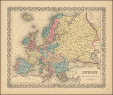
This extraordinary portolan chart of the European World, dating to circa 1360, is one of the finest cultural artifacts from the early Renaissance still in private hands. Likely drawn in Venice, this masterwork embodies the dawn of precise, modern cartography, and Europeans’ nascent interest in lands far beyond their own borders; an interest that, in the closing years of the following century, would spill across the globe and forge the world of today. This map stands nearly alone as a cartographic relic of its era; no older complete chart exists anywhere outside of Europe.
Now known as the Rex Tholomeus portolan chart, based upon the fine full-length portrait of Ptolemy at the bottom right, the chart was created in the tumultuous aftermath of the Black Death and about 130 years before Columbus first reached the New World. The chart extends from the scarcely-known islands of the open Atlantic to the expansive Eurasian steppes of the Golden Horde. In the west, it shows the convoluted borders of the Hundred Years' War, the crescent flag over the last Muslim kingdom in Iberia, and the most complete mapping of the British Isles up to that point. In the east, the chart illustrates the remnant Crusader strongholds on the fringes of the Levant, their Mamluk conquerors, and the final bastions of the Byzantine Empire. In the north, an unusually rich rendering of Norway depicts the gyrfalcons that so captivated medieval nobles.
In the south, the chart’s inclusion of a full-length portrait of Ptolemy, predating the rediscovery and translation of his Geographia by Jacopo Angeli in 1410, adds considerably to our understanding of the early Renaissance perception of that famous 2nd-century geographer. This fascinating detail sheds light on the developing humanist interest in ancient geographical knowledge and the burgeoning awareness of Ptolemy's significance in the field of cartography.
History & Provenance of The Chart
The Rex Tholomeus portolan was first discovered by Italian scholar Pietro Amat di San Filippo in 1888, in the library of Prince Corsini’s magnificent palace along the banks of the Arno River in Florence. One of at least 4 portolan charts in the Corsini collection at the time, Amat di San Filippo tentatively dated it from 1347 to 1354.
Over the following 4 decades, the Rex Tholomeus portolan was included in several other published studies, each concluding that it was drawn in the 14th century. The final and most detailed study, by Arthur C. Hinks in 1929, concluded that this chart was the single important omission from Kretschmer’s foundational 1909 catalog of early portolans.
In the first part of the 20th Century, the chart passed into famed Florence-born Anglo-Italian photographer John Alfred Spranger’s great private collection of Renaissance texts, where it remained for most of the 20th century. The chart reappeared twice at auction, first at Christie’s in 1993 and again in 2022; there, without the benefit of earlier scholarship, catalogers erroneously dated it as late as 1530.
Recent Research, Carbon Dating & Multispectral Imaging
Since acquiring the Rex Tholomeus portolan chart in December 2022, we have followed the threads uncovered by those who first examined it in the late 19th and early 20th centuries. We have built upon their findings by more closely examining the chart’s geography and toponymy, including the geopolitical significance of its dozens of colorful pennants. In addition, we have shared the chart with the world’s leading portolan experts and subjected it to carbon-14 dating and multi-spectral imaging. After this exhaustive study, we have confirmed what the early scholars thought: that this chart most likely dates from the middle of the 14th century.
While bearing important continuities with other 14th-century portolans, Rex Tholomeus portolan chart also includes a host of atypical features and unique cartographic content. As a result, it cannot be classed with any known school of portolan making and represents a new and previously unrecognized tradition. That said, the chart's toponymic conventions, sporadic use of the Venetian vernacular, and strong iconographic preferencing of Venice over all others have led us to conclude that it was very likely made in that city.
Conclusion
As documented by the MEDEA Chart Database, the leading census of early portolans, this chart is one of the four oldest complete modern maps of Europe in existence, and the only one outside of Europe. It is predated only by the three charts associated with Angelino Dulceti (at the BnF, BL, and Corsini Collection). Crucially, the chart boasts stellar provenance and is unencumbered by the export restrictions that often affect manuscript items in Europe.
That this chart is much older than any acquired by Henry Huntington, J. P. Morgan, or James Ford Bell, the great portolan-hunters during the bountiful collecting years of the first part of the 20th century, underscores the virtual absence of such items in the antiquarian market. The importance of this chart for the history of cartography has only just begun to be unraveled, but it is already clear that it has the potential to transform our knowledge of the birth of modern mapmaking.
The Complete Cataloging Can Be Found Here: lllustrated Catalog
![[Stop The Fake News!] Halte au Menteurs! Les Colo Bacilles Sement La Haine!](https://storage.googleapis.com/raremaps/img/small/59951.jpg)


![(Second World War - Prelude to War) Die Luftbedrohung Deutschlands [The Air Threat to Germany]](https://storage.googleapis.com/raremaps/img/small/84075.jpg)