|
||

|

|
|

|
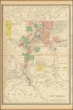
The First Commercially Published Map Of New Mexico Territory
Fine example of this rare map of New Mexico Territory, the only obtainable commercial map to illustrate New Mexico Territory in its early configuration.
The map appeared in the extremely rare Rogers & Johnston Atlas of the United States. The map was derived from the monumental and equally rare wall map, a historic collaboration between Professor Rogers, the American, and the Johnston publishing house in Britain.
The map is colored by counties and shows a number of interesting details, including towns, springs, Indian details, topographical information, forts, mountains, etc. A portion of Southern Colorado appears in New Mexico, as does all of Arizona and Las Vegas, Nevada.
The map is very rare on the market.

![(Santa Fe, New Mexico Photograph) From Francisco Street, Up [Original cabinet card photograph of Santa Fe, New Mexico street]](https://storage.googleapis.com/raremaps/img/small/92949.jpg)