


|
||

|

|
|

|
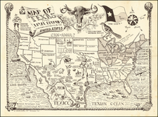
Scarce vintage Texas pictorial postcard map, in the same molds as the famous "Texas Brags" map. This example published by John Randolph in Tomball, Texas in 1951.
The map is filled with humorous superlatives about Texan landmarks, products, and culture. Texas has the "Richest People", the "Plains of Texas contain more nothing than any place on earth!", "TV Star? No, Politician", "Cryingest Onions", etc.
Below the map it says:
Texas occupies all of the continent of North America except a small part set aside from the United States, Canada, and Mexico. It is bounded on the north by 30-odd states, on the east by all the oceans except the Pacific, on the south by the Texas Border and on the west by the Pacific Ocean and the rest of the world.
Texas Is:
SO BIG that they practice 'round the world flying here without ever crossing the border!
SO FLAT that they put signs up to tell the rivers which way to run!
SO WILD that not even the law of gravity is obeyed!
SO WOOLLY that they supply 35% of the U.S. wool and 90% of the mohair and still have enough left to pull the wool over your eyes!
Texans Are:
SO PROUD that it takes 10-gallon hats to contain the swellhead!
SO RUGGED that the wild Indians, buffalo herds and longhorns just gave up and disappeared!
SO INDEPENDENT that they have their own Independence Day (March 2nd, when they became an independent nation in 1836.)
SO HOSPITABLE they don't care who comes to Texas! [Except if they're Californians...]
![A Hysterical Map Of The Yellowstone Park -- With Apologies To The Park -- Smileage Guaranteed [with mailer]](https://storage.googleapis.com/raremaps/img/small/87036.jpg)