This item has been sold, but you can enter your email address to be notified if another example becomes available.


|
||

|

|
|

|
Stock# 6672
Description
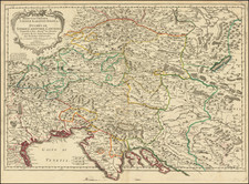
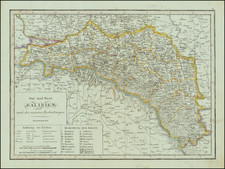
Highly detailed and attractive map of the German Empire, extending from the North Sea and the Rhine in the west to the Bug River in the East, including all of Poland, Galizia, Austro-Hungary and Transylvania. Bounded by the Ottoman Empire in the South and the Baltic in the North. Shows towns, roads, rivers, various Duchies, principalities, railraods, mountains, etc.. The German Confederation numbers 40 states listed in the key. Attractive swash letter title with a decorative piano key border. A fine wide margined example, from Andriveau's Atlas Universel, published in Paris.
![(Second World War - Postwar Reconstruction) [Archive of Materials Related to American Reconstruction Efforts in Bavaria]](https://storage.googleapis.com/raremaps/img/small/88055.jpg)