


|
||

|

|
|

|
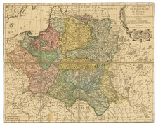
Detailed map of East and West Galitzia, showing towns, provinces, states, roads, rivers, etc.
An interesting and scarce map from this well regarded Viennese publisher.
The map's legend, "Erklärung der Zeichen," details various symbols used to represent towns, saltworks, markets, silver, lead, post stations, iron, glass factories, mines, universities, and ecclesiastical jurisdictions, among other features. This array of symbols illustrates the region's diverse industrial, educational, and religious aspects, offering a multifaceted view of Galician society and its infrastructure.
The delineation of districts ("BENENNUNG DER KREISE") and their respective key features, such as "Städte" (cities), "Salzsiedereyen" (saltworks), and "Bergwerke" (mines), reflects the economic activities and administrative divisions of the time. The inclusion of specific resources like "Salz" (salt), "Silber" (silver), "Bley" (lead), and "Eisen" (iron) indicates the presence of mining and metallurgical industries, which were crucial to the region's economic development. Moreover, the map's depiction of "Poststation" (post stations) and various religious establishments highlights the importance of communication and religion in Galician society.
The classification of towns into different categories, such as "Märkte" (markets) and "Universtät" (university), provides additional context regarding the urban centers' roles within the region. For instance, the mention of "Armenisches" (Armenian) and different religious affiliations, including "Kathol Erzbisthum" (Catholic Archbishopric), "Grichisch unirtes" (Greek Catholic), and "Grichisch nicht unirtes" (Greek Orthodox), reflects the complex tapestry of ethnic and religious communities in Galicia.

![(Second World War - Holocaust) Walki z najezdzca Hitlerowskim I zbrodnie Hitlerowskie na terenie wojewodztw: Bialostockiego, Lomzynskiego i Suwalskiego w latach 1939-1945 [Fights with the Nazi invaders and Nazi crimes in the following voivodeships: Bialostocki, Lomzynskie and Suwałki in 1939-1945]](https://storage.googleapis.com/raremaps/img/small/82911.jpg)
![[Lithuania / Western Belarus] Partie De Lithuanie ou sont les Palatinats de Wilna et Troki, subdvises en leurs Chastellenies. et Parti du Palat.at de Minsk. . . . 1665](https://storage.googleapis.com/raremaps/img/small/76057.jpg)
![Повстанцы 1863 Года [(Polish) Insurgents of 1863]](https://storage.googleapis.com/raremaps/img/small/52719.jpg)