


|
||

|

|
|

|
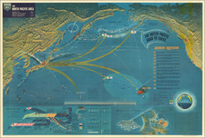
Rare “BIGOT”-rated photomosaic planning map for the D-Day landing at Utah Beach.
A rare composite photographic map prepared for the D-Day landing at Utah Beach. From the Neptune Monograph, the definitive briefing book issued to senior American officers in preparation for the landings, and bearing the ultra-secret “BIGOT” classification.
“… nothing was more secret—or more vital to Operation Neptune—than the mosaic of Allied intelligence reports that cartographers and artists transformed into the multihued and multilayered BIGOT maps.” (Thomas B. Allen, “Untold Stories of D-Day,” National Geographic Magazine, June 2002, vol. 201, no. 6, p. 15)
The original plan for Operation Overlord called for three Allied divisions to land in Normandy along a 25-mile front, but at the insistence of Eisenhower and Montgomery the scope was expanded to include five divisions landing along a 50-mile front. The revised plan included a landing at what is now known as Utah Beach, on the east side of the Cotentin Peninsula, so that Allied forces could drive west and north to capture the critical port at Cherbourg. The main force assigned to the landing at Utah was the American 4th Infantry Division, supported armor from the 70th Tank Battalion and airborne strikes inland by elements of the 82nd and 101st Divisions.
Offered here is a remarkable photographic composite map assembled from aerial photographs of the landing beach and the surrounding countryside. These were made by a reconnaissance aircraft on January 5, 1944, when the Allies already had substantial air superiority over Luftwaffe.
The map depicts some six miles of beach along the east side of the Cotentin Peninsula and at one point extends perhaps four miles inland. The resolution is sufficient to delineate roads and tracks, hedgerows and individual structures. To deter invasion, the Germans had flooded miles of farmland behind the beach, and I believe that these areas appear darker in the image. Notations indicate roads running inland from the beach, which would have provided key lines of advance for the 4th Division on June 6.
In the end, strong currents swept the first wave of the 4th Division’s landing craft some 2000 yards south of the planned landing zone, and they came ashore in the vicinity of La Grande Dune, not show on the map (A comparison of the planned and actual landing sites can be viewed here.) The Division’s second-in-command, Brigadier General Theodore Roosevelt, Jr., determined that this spot was in fact better than the planned location up the beach, and the successive waves of troops were directed to come ashore there.
Though it did not achieve all of its objectives for Day One, the landing at Utah was overall a great success: The 4th suffered relatively few casualties during the landing, gained control of the beach within just a few hours, and by the end of the day had penetrated several miles inland.
The BIGOT classification
The map originally appeared in a copy of the Neptune Monograph, a secret briefing book issued in late April 1944 and summarizing Allied intelligence related to the Normandy landings, with particular emphasis on the American sector including Omaha and Utah Beaches. Containing information of the highest sensitivity, the Monograph bore the distinctive “BIGOT” stamp, the highest level of military security classification, and it was printed and distributed in small numbers. Likewise, this map bears the label “TOP SECRET BIGOT”.
Introduced during the Second World War, some sources suggest the BIGOT designation was an acronym for “British Invasion of German Occupied Territory;” others, that it was a “backronym” for “To Gib,” the code stamped on the papers of officers headed to Gibraltar in advance of the 1942 North Africa invasion.
Whatever the origins of the term, extraordinary efforts were made to protect BIGOT-level material. When for example a practice landing (“Operation Tiger”) on the Devon coast was ambushed by U-Boats, Eisenhower himself ordered the recovery of the bodies of the ten known victims with BIGOT clearance. This was necessary to prove that they had not been captured alive, as their capture would have compromised the invasion plans and necessitated its cancellation.
In all, a rare artifact from the run-up to one of the most significant, dramatic and terrifying events in American military history.
![(Second World War - The Budapest Ghetto) Budapest székesfőváros VII. ker. térképe [Map of the VII Area in the Capital City of Budapest]](https://storage.googleapis.com/raremaps/img/small/90122.jpg)
![[ Rare Imprint -- Theater of War in Europe ] Le Royaume de France divise en Toutes ses Provinces / Groot Toneel des Oorlogs, tusschen de Geallierrede Moghendhen en het Fransche Ryk -- Grand Theatre de la Guerre entre les Puissances Alliees et L'Empire Francois . . .](https://storage.googleapis.com/raremaps/img/small/104046.jpg)