|
||

|

|
|

|
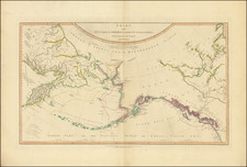
Rare map of the Nome Gold Belt, stretching from Cape York to Norton Bay, published to promote the Pioneer Line, C.M. Hamilton & Company, General Agents in Seattle.
The map was drawn from observations made by W. H. Rowe. While not further identified in the map, W. H. Rowe was a resident of Montpelier, Vermont and manager of the Vermont Klondike Expedition, which travelled to Alaska from Montpelier, Vermont in 1898. As noted below, over a dozen Vermont newspaper give detailed (and undoubtedly promotional) accounts of Rowe's time in Alaska, his intent to return and glowing reports of its commercial prospects. On February 27, 1902, W. H. Rowe was granted a revocable license to construct, operate, and maintain a telephone line along the beach or shore line of the United States Fort Davis Military Reservation. December 27, 1905, to the Seward Cooperative Telephone Co., to construct, operate, and maintain a telephone line.
Later newspaper accounts report that Rowe would come to own a steamer running between Seattle and Cape Nome by 1904 (Waterbury Record, May 10, 1904) and remained engaged until at least 1907.
The map includes pencil annotations in Norton Bay, making a number of references to the Roanoke, one of which mentions the S.S. Roanoke, as well as notes in several places referencing "Nugget." The lead story in the July 20, 1898 edition of the Seattle Post-Intelligencer was the docking of the Roanoke in Seattle with four tons of gold from Alaska aboard. After the discovery of gold at Nome, Alaska in September 1898 precipitated the Nome Gold Rush, the Roanoke's route was modified to end at Nome. The Roanoke remained serving the Alaska route until at least June 1904.
The map shows a number of different mining districts, including:
- Nome
- Bonanza
- Eldorado
- Discovery
- Blake
- Big Four
- Sinook
- Cripple Granite
- Fairview
- Cape York
- Norton Bay
In addition, a list of the 5 Steamers of the Pioneer Line are given, showing the sizes and passenger capacity, with pencil annotations replacing the S.S. Hueneme with "Nome City," and another pencil note referencing "Pacific Coast". Early newspaper articles reference the Nome City as operating on the Pioneer Line as early as September 1900, so this ship must have been added about the time the map was published. We don't see a reference to the Hueneme after January 1900, so perhaps it ceased operating on this line.
W. H. Rowe
The first newspaper account of Rowe's time in Alaska is found in the Montpelier Evening Argus of April 2, 1900, which reports:
W. H. Rowe and his family have returned from Alaska and are spending a couple of weeks at the Montpelier house. They will go back again on May 1, Mr. Rowe will be remembered as the manager of the Vermont Klondike expedition which went away from Vermont in 1898. He made his headquarters in the city for several months and a part of 65 or so went with him.
Mr. Rowe has struck it rich, and says that all he wants is three years more. He expects to have a half million with which he will be satisfied. He is very enthusiastic and says that the Cape Nome district, in which he is located, is the greatest gold filed the world has ever known. . . .
Mr. Rowe was accompanied to the ice clad hills of Alaska by his wife and two sons [14 and 15 years old]. They spent the winter of '98 in Council City, which lies about 40 miles from Cape Nome . . .
. . . Mr. Rowe went to Alaska suffering dyspepsia and now says he can eat a three-inch plank with nails in it.
Mr. Rowe's stop in Cape Nome district was an accident. The part was delayed on the way and reached St. Michaels July 25, 1898, just in time to hear of the Cape Nome strike. there were bound for Dawson City, but gave up this trip and struck out for Nome, being among the first to arrive . . .
Mr. Rowe and a number of Vermonters located in the Blake District . . . He has 21 claims on Fox River, and is the recorder of that district for miners.
. . . [Rowe] . . . has organized the Rowe Mining company . . . .incorporated under the laws of the state of Washington . . .
Mr. Rowe has drawn one of the most complete maps of the Cape Nome district that has even been issued, and it is used by all the transport companies. It was made by him from personal observations and investigation. On his prospecting tours in the winter of 1898 he slept out many nights with the thermometer ranging from 30 to 50 below zero.
. . . On the map which Mr. Rowe has prepared of the Cape Nome district are two mountain peak named for his sons, Hugh and Guy. They were probably the first white bosy that ever had trod the tops of these mountains. . . .
Rarity
We locate two examples. Yale and University of Washington
![[ Anchorage in the Future ] Anchorage and the Cook Inlet Basin - Captain Cook Returns 2035 A.D.](https://storage.googleapis.com/raremaps/img/small/78278.jpg)
![[ Routes to the Gold Regions ] Explorations in Alaska 1899 Route From Lynn Canal Via Headwaters of White and Tanana Rivers to Eagle City](https://storage.googleapis.com/raremaps/img/small/98762.jpg)
![[Bering Land Bridge, Alaska] Teller-Kougarok Area Compliments of Lomen Commercial Company Nome, Alaska](https://storage.googleapis.com/raremaps/img/small/45000jc.jpg)
![[Map of Russian Possessions in North America] Карта Российскаго Владѣнія въ Сѣверной Америкѣ](https://storage.googleapis.com/raremaps/img/small/66569.jpg)