


|
||

|

|
|

|
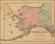
Extremely Rare Russian-Language Map of Russian America (Alaska).
Detailed engraved map of Alaska, labeled "Russian Possessions", published in Saint Petersburg in 1836.
This is one of very few contemporary Russian maps to focus specifically on Russian America. Two of the other Russian maps to focus on Alaska from this period are the Piadychev and the Zagoskin.
The following four Russian settlements are identified and labeled:
- Кр. 3. Святителей (Fort 3 Saints, Kodiak, Alaska)
- Кр: Александровская (Fort Alexander, Graham, Alaska)
- Воскресенская Верфь (Resurrection Shipyard, Resurrection Bay, Alaska)
- Новоархангельскъ (New Archangel, Sitka, Alaska)
A note in the lower-left corner translates "Fort Ross is on Map N. 31."
This is a later state of the map, as there is evidence of erased engraved lines throughout the map image.
Rarity
We are unable to find any other examples of this map whether in libraries or archives, sales databases, nor in general online searches.
The map comes from the 1836 edition of Всеобщий атлас или собрание карт всего земного шара, изданный для пользы юношества и сверенный с географиею Арсеньева и других Федором Позняковым. Второе издание, исправленное и дополненное 7 картами, выгравированными г. Фроловым. This translates as The universal atlas or collection of maps of the entire globe. Published for the benefit of youth and verified by the geography of Arsenyev and others by Fyodor Poznyakov. Second revised edition with additional 7 maps engraved by g. Frolov. That atlas was first published in 1829 (with an additional run printed in 1833), then for this second edition in 1836, and again in 1843 as the third edition. The second edition is in neither the RSL nor NLR.
Fyodor Poznyakov (1797-1835) was a Russian military topographer and mapmaker. He began his career in 1822. He supervised the 1825 General map of Asian Russia by the latest division into provinces, regions, and coastal administrations [Generalnaya karta Aziatskoy Rossii po noveyshemu razdeleniyu na gubernii, oblasti i primorskie upravleniya].
Konstantin Arsenyev (1789-1865) was a Russian academic, scientist, topographer, statistics specialist. He was an important figure of his era, held the title of Privy Councillor, was teaching geography to Alexander II - while being an avid advocate of the free peasant labor as opposed to serfdom. Arsenyev also was one of the founders of the Russian Geographical Society. His textbook "Brief General Geography" - first published in 1818 - was the most important textbook on the topic for over 30 years.
![Charte von Nord-America Prag 1818 [Rare Alaska Inset Map]](https://storage.googleapis.com/raremaps/img/small/72184.jpg)

![[Anchorage, Valdez and Prince William Sound] Cote Nord-Ouest De L'Amerique Reconnue par le Cape. Vancouver VIe. Partie . . .](https://storage.googleapis.com/raremaps/img/small/92676.jpg)