
This item has been sold, but you can enter your email address to be notified if another example becomes available.


|
||

|

|
|

|
Stock# 66418
Description
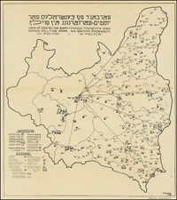
Fascinating map of Poland, published by the Instytut Gospodarstwa Społecznego.
The map was prepared by Edward Wacław Maliszewski, a Polish bibliographer, historian, ethnographer, journalist, researcher of national relations in Poland. The map illustrates a range of historical and proposed new boundaries relating to the treatment of the post-World War I border between Poland and Germany. A total of 13 different borders are illustrated.
From January 1919 to January 1920, a peace conference was held in Paris, which made decisions about the future political boundaries of Europe after World War I. The subsequent Versailles Treaty regulated the formation of new western borders with Germany, but not the eastern border with Poland.
![[Western Poland / Northeastern Germany] Lusatia Superior Ex Officina Davids Funck Norimbergae](https://storage.googleapis.com/raremaps/img/small/91153.jpg)
![[ Silesia / Southwestern Poland ] Schleisien in nieder-und ober Schlesien, ndann in Furtenthumer eingethelt, nebt der Grafschafte Glatz](https://storage.googleapis.com/raremaps/img/small/102990.jpg)
![[ Holy Roman Empire ] Germania del Gastaldo](https://storage.googleapis.com/raremaps/img/small/73754.jpg)
![[Warsaw] Varsovia](https://storage.googleapis.com/raremaps/img/small/91087.jpg)