|
||

|

|
|

|
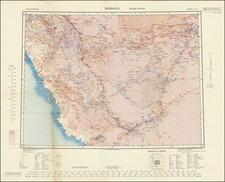
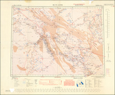
Highly detailed map of the Arabian Peninsula, published by the British Ministry of Defense in 1980.
The map presents a detailed over view of the Peninsula, including roads, railroads, airports, landing fields, Ruins, water pipes, Drilled wells, Dug Wells, Ancient Surface Wells (Birkah), Ancient water tunnels, Oil fields, Oil pipe lines, Oil Terminals, Pumping stations, refineries, and many other features.
The map includes a list of 12 cartographic sources. The map notes:
Compiled by the U.S. Geological Survey and the Arabian American Oil Company under the joint sponsorship of the Kingdom of Saudi Arabia, Ministry of Petroleum and Mineral Resources, and the U.S. Department of State.
Revision of U.S. Geological Survey Miscellaneous geological investigations map I-270 B-1, 1958.
Reproduced by Mapping & Charting Establishment (RE) with amendment of political information and addition of boundaries, June 1972.
Not distributed to depository libraries.
Copyright HMSO London 1980.