


|
||

|

|
|

|
An 18th Century American Map Not Recorded in Wheat & Brun.
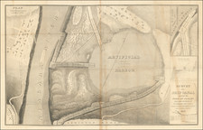
A remarkable discovery, a hitherto unknown map of the so-called Watkins and Flint Purchase in what was then the Tioga County region of western New York State, just south of Cayuga and Seneca Lakes.
The map depicts the roughly four hundred thousand acres granted to New Yorkers John Watkins and Royal Flint in 1794. It is based on a 1791 survey, which divided the tract into twelve townships, each in turn subdivided into quarter townships. Reflecting the complex state of land ownership in New York at the time, the boundaries of dozens of previously-granted tracts within Watkins’ and Flint’s holdings are carefully delineated. No topographical detail is given, but rivers and streams—the presence or absence of which was a vital factor in land values--appear to be delineated with some care.
Further indicating the tangled state of land ownership at the time, the Purchase is shown bounded to the north by the “Military Lands” retained for grants to Revolutionary War veterans; to the northwest by the “Purchase of James Watson;” and to the west by the “Preemption Line” and the Gorham and Phelps Tract. Each of these has its own intricate story which will not be addressed here; however, click on these links for detailed discussions of the Military Lands and Gorham and Phelps Purchase.
The map is neither signed nor dated, but it was almost certainly produced at the behest of Watkins and Flint, or perhaps their agent, with an eye toward selling off portions of the purchase to recoup their investment. The historical circumstances of the Purchase, the map’s physical characteristics (engraving on laid paper), certain features of the boundaries shown (more on which below), and the stylistic similarities to other maps of the genre all support a dating to the mid-1790s.
The map is absolutely unrecorded in the usual sources, and we have been unable to locate any examples in institutional or private collections. In particular, it is not described in Wheat & Brun’s Maps and Charts Published in America before 1800 (1969), a remarkably thorough and complete survey that remains the “Bible” for maps of this period.
Background
The cost of financing the Revolutionary War, the ravages of that war, and the subsequent economic dislocation left the U.S. government and individual American states deep in debt, without reliable sources of recurring revenue. For many states a primary means of raising funds, while at the same time stimulating settlement and economic development, was the sale of public lands. Sometimes these sales were of small parcels to people of modest means, but in other cases vast tracts were transferred to syndicates of wealthy and influential investors and speculators. In New York State, the most famous of these was the Holland Land Company grant, but there were also the Gorham and Phelps Grant, the Robert Morris Purchase, and the Watkins and Flint Purchase.
John W. Watkins was a New York lawyer and property speculator, who had married into the prominent New York land-owning family, the Livingstons. Royal W. Flint was a New York speculator in the financial markets, one of the individuals involved in creating the “Panic of 1792”, in which speculators exploited easy credit to drive up the price of Federal bonds, which investors needed as scheduled part-payment towards their purchase of shares in the Bank of the United States. When the leading figures defaulted on their loans, the market crashed. Many investors were ruined, but Flint had already taken his profits, some of which he deployed in land speculation.
In 1791, Watkins and Flint applied to the New York Land Office to purchase land in the state. Their application was not approved until 1794, the patent was granted on 25th June 1794, and the men moved quickly to dispose of the lands, within a year selling about one-third of the purchase to another speculator, Robert C. Johnson.
A survey of the lands was undertaken in 1791, when New York Surveyor General Simeon De Witt ordered Laurence Vrooman to survey the parcel. The survey was less than perfect, leading inevitably to litigation, and we learn much from the 1839 State Supreme Court judgment. In brief, the case arose from the actions of one of Vrooman’s assistant surveyors, by the name of Sabin, who was entrusted with surveying the central east-west line through the northern tier of six townships in the Purchase. Unfortunately, he constructed his survey line between 20 to 24 chains too far north (between 1320 and 1584 feet), and this error was only noticed when he was just over half-way (about twenty-two miles) through the survey. He ignored the direction to start over, simply adjusted the line on paper, and then completed the survey, which he submitted to Vrooman, and was so-shown on Vrooman’s map. The discrepancy was only noticed in 1799, when a James Pumpelly was surveying the boundaries of township no. 7 and found that that Sabin’s surveyor’s blazes on the ground did not tally with the map of the Purchase he had to hand. He duly reported his findings to his principal, hence the sequence of court hearings to establish whether the map or the survey represented the correct boundary line, and who owned the land between the Sabin and Pumpelly lines. (John Lansing Wendell, Reports of Cases Argued and Determined in the Supreme Court of Judicature and in the Court for the Correction of Errors of the State of New York (Albany, 1839), vol. xviii, pp. 158-59, the case pp.157-69)
Dating the map
It seems likely that Vrooman’s original survey as supplied to the Surveyor General’s Office is the basis for this map. It would, however, only make sense for Watkins and Flint to commission a printed map of this title after the patent was confirmed in June 1794, as an aid to marketing the land. The inherent time lag in creating the printing plate suggests it was probably printed either in late 1794 or early 1795.
Interestingly, the 1839 Supreme Court judgement refers to
a deed from John W. Watkins to James Greenleaf, bearing date 30th December, 1794, with a map of Watkins and Flint's purchase attached thereto, conveying, among other tracts, the tract known and distinguished on a certain map or chart now on file in the office of the surveyor-general of the state of New-York, by the southwest quarter of township number ten. It appeared from the map, that Watkins and Flint's purchase was divided into quarter sections.
It might be that the map attached to the deed was manuscript, but it could be this printed map annotated for the purpose of the transaction.
In all, a significant discovery of a map “not in Wheat & Brun”, representing the only recorded example of the only recorded printed map to depict the Watkins and Flint grant, at this important juncture in the history and settlement of the region.

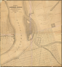
![[ Battle of Saratoga ] Plan of the Position which the Army under Lt. Gen. Burgoine took at Saratoga on the 10th of September 1777 and in which it remained till the Convention was signed.](https://storage.googleapis.com/raremaps/img/small/103578.jpg)