


|
||

|

|
|

|
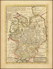
Rare ethnograhic map depicting the territory of modern Dagestan Republic in Russian Federation.
The Dagestan region de jure became a part of the Russian Empire in 1802, but de facto the citizens, united by the Muslim ethics, always saw themselves as free and independent gortsy (the highlanders), they fought for their independence and a number of times they were an unrecognized independent state. Dozens of terroristic acts were carried out as late as in 2000’s by the Dagestan radicals in an attempt to spread their separatist ideas.
There are 30 ethnicities on the map, including Persians, Tats, Avars, Tatars, Kubachintsy and Jews. In 1890’s there were ca. 570 000 inhabitants of the region.
The map appeared in rare Kavkazskiy Kalendar’ (The Caucasian Calendar) in late 1890’s
The author of the maps and the data, lieutenant-general Elisey Isidorovich Kondratenko (died 1906), was a prominent Russian researcher and politician. Among other titles he held, Kondratenko was the Head of Caucasian department of the Russian Geographic Society. The map is from the ethnographic studies of Zakavkazskiy kray region from his study Etnograficheskie karty guberniy i oblastey Zakavkazskogo kraya originally published with a separate atlas (the atlas held 7 plates) in 1893. Kondratenko also was the editor-in-chief of the Kavkazsky Kalendar’ where he published those maps for those who were unable to obtain a copy of his 1893 study. Those are the first detailed ethnographic maps of the Caucasian region ever.
The data on those maps was made using the information from family lists from each settlement. This data was given to him by State censor and Head of the Caucasian statistical committee Nikolai Zeidliz - who acquired it via his connections in Russian state police (it means that the most of the data used in those maps is barely illegal) and who made the first general Caucasian ethnographic map in 1880. Because of sources, the data was more accurate and differed from the official statistics of region’ cameral descriptions.

![[Uniforms and Insignia of the German Army] Форма Обмундирования и Знаки Различия Германской Армии](https://storage.googleapis.com/raremaps/img/small/67803.jpg)


![Повстанцы 1863 Года [(Polish) Insurgents of 1863]](https://storage.googleapis.com/raremaps/img/small/52719.jpg)