|
||

|

|
|

|
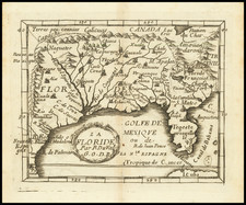
The Lost Moses Pitt / John Thornton Map -- First English Map of the Spanish Main
The only complete surviving example of John Thornton's 3 sheet map, the earliest English map of the Spanish Main and a map which was unknown to Burden and other scholars until recent years.
Focused heavily on the Spanish activies (and English aspirations) in the region and most notably the weath of Gold and Silver passing through the Spanish ports in the region, the map provides the first large scale image of the Gulf of Mexico, Florida and the Caribbean published in England. Below the title, a passage provides a look at the English designs expanding its colonial holdings and trading presence:
We have no plantation in the Indies adventageously seated but Iamaica. then which indeed nothing can lye better, wherefore it is the English interest to plant no more behither it; but to remove rather our north Collonys and those in the Caribe Islands and fix them toward Jucatan Capt Grtias dios Panama or Cartagena for were but the English of Nevis Montsoratt St. Christopher and Antega placed on those coasts we should soon obtain a vast trde vending as many of our commodities as we could carry over: this neighborhood of ye English would much more advantage and secure the Spanierds also
The map specifically notes that in 1670, the "Istmus and towne of Panama was taken by ye English and kept 28 days," a feat accomplished under the leadership of the Welsh privateer Henry Morgan, who would go on the be Lieutenant Governor of Jamaica. It also provides an interesting passage suggesting the future aspirations of English trade in the East and West Indies, noting at the bottom below the words South Sea:
Panama lyes in the center of trade north and south between Mexico and Peru and the mines of Sacatecos and Potossi east and west between Europ and the East Indies it being but 7 weeks sayle ether from England or Iapan so yet had be but to pass this way we might manage the East and West India trade under one voyage and with Speed returnes it being but 15 miles by land from Panama to Venta de Cruzes.
The Lost Pitt Map
Until 2009, there were no known surviving examples of this map, until Philip Burden discovered an example of the map lacking the western sheet (Gulf Coast), which was bound into the Innys Atlas at Holkham Hall in Norfolk, England. Burden had previously identified the possible existence of the map in Volume II of his Mapping of North America in the Lost Map Section (Appendix 1), noting that:
The Term Catalog for Trinity Term 1673 (May 6, 1673 I. 135) announced "A new Map of the Trading Part of America, both Continent and Islands . . . " Priced at 1 shilling it was "Sold by Moses Pitt in Little Britain.
Burden notes:
The reference to the Isthmus relates to the infamous sacking of Panama in December 1670 by Henry Morgan against a much larger force. This Welsh pirate held the city for twenty-eight days and razed it to the ground. A legend off the Panama coast reflects these events. This and other exploits against Spanish towns in the Caribbean gave the English substantial prizes. As a reward Morgan was knighted and appointed Lieutenant Governor of Jamaica in 1674.
The title goes on to refer to the fact that the map was published by a private gentleman. The speculation about his identity could be endless. . . Indeed it is interesting to note that the engraver here also appears to be the same person behind John Thornton’s A New/ Mapp of the north part of/ AMERICA published in February of the same year, 1673. It is particularly interesting to note that where that map finishes in the south is along the Carolina-Florida border, just where this map starts. Was Thornton involved in it from the start?
A further area of note is the English colony of Port Royall A colony of Engl. identified on the west coast of the Yucatan Peninsula. This refers to the valuable settlement which supplied logwood to ships including privateers from Jamaica through much of the seventeenth and eighteenth centuries. In the previous year the Governor of Jamaica, Sir Thomas Lynch, had reported trouble with the Spanish to the Council for Plantations.
Pitt is one of many pioneering Englishmen in the field of cartography in the seventeenth century . . . His main area of interest was in scientific works, and he had many connections with the Royal Society, a member of which, Robert Hooke, was one of his largest clients. Hooke . . . may well have been the private individual behind this map. Certainly the members of the Royal Society had extensive connections with the Plantations of Jamaica. . .
Morgan As Private Gentleman?
Burden's suggestion that the source of the map could be Henry Morgan is an intriguing one. During Morgan's absence from Jamaica, news reached the island that England and Spain had signed the Treaty of Madrid. The pact aimed to establish peace in the Caribbean between the two countries, including revoking the privateering commissions which had tacitly approved the taking of Panama by Morgan.
Morgan's destruction of Panama so soon after the signing of the treaty led to what Allen describes as "a crisis in international affairs" between England and Spain. The English government heard rumors from their ambassadors in Europe that the Spanish were considering war. In an attempt to appease them, Charles II and his Secretary of State, the Earl of Arlington, ordered Morgan's arrest. In April 1672 the privateer admiral was returned to London where, he hailed as a conquering hero and compared to Sir Francis Drake.
Morgan probably remained at liberty throughout his time in London, and the political mood changed in his favor. Arlington asked him to write a memorandum for the king on how to improve Jamaica's defenses. Morgan was never charged with an offense, but did give informal evidence to the Lords of Trade and Plantations and proved he had no knowledge of the Treaty of Madrid prior to his attack on Panama. In January 1674, John Vaughan, 3rd Earl of Carbery was named Governor of Jamica and Morgan his deputy. King Charles appointed Morgan a Knight Bachelor in November 1674, and two months later, Morgan and Carbery left for Jamaica.
The publication of the map certainly corresponds with the timing and rehabilition of Morgan's name during his time in England.
States of the Map
While Burden speculates that there may be more than one edition of the map, there seems for the moment to be no tangible evidence of the survival of an earlier state.
The present map is the complete 3 sheet version of the map in original color, which was recently discovered in a small local auction and acquired by Barry Lawrence Ruderman Antique Maps in October 2019. It differs from the example discovered by Burden, which was lacking the western most sheet, covering the western part of the Gulf Coast, from the mouth of the Mississippi River and the Gulf Coast of Texas and Mexico to just west of the Yucatan.
Rarity
The complete 3 sheet example is known in just this one example.
The 2 sheet version of the map survives in a single confirmed example (Holkham Hall, Norfolk, England). The Bibliotheque National de France also now lists a 2 sheet example in its catalog.
John Thornton was a respected and prominent chartmaker in London in the latter part of the seventeenth century. He was one of the final members of the Thames School of chartmakers and served as the hydrographer to the Hudson's Bay Company and the East India Company. He produced a large variety of printed charts, maps, and atlases in his career, but he was also a renowned manuscript chart maker. Born in London in 1641, he was apprenticed in the Drapers Company to a chartmaker, John Burston. After being made free of the company (1665), he was part of the combine that took over John Seller’ English Pilot in 1677. Thornton was trusted by the naval and navigational establishment of the day; one of his clients was Samuel Pepys, naval administrator and diarist. Thornton died in 1708, leaving his stock to his son, Samuel, who carried on the business.
Samuel, born in ca. 1665, also had apprenticed in the Drapers Company and was made free a year after his father’s death. He continued the business until 1715, when he died. His stock then passed to Richard Mount and Thomas Page.
![[Manuscript Map, Michoacan, Mexico]](https://storage.googleapis.com/raremaps/img/small/65663ba.jpg)
![[War of Jenkins Ear in Florida and West Indies] [Harbors, Towns & Fortresses of North America, St. Augustine, Providence (Grand Bahama Island), Porto Antonio (Jamaica), Havana, Santiago (Cuba), Kingston, and Antiqua)]](https://storage.googleapis.com/raremaps/img/small/75642.jpg)