|
||

|

|
|

|
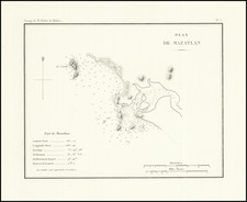
18th Century Mexican Manuscript Map Describing A Dispute Over Water and Land Ownership Rights
This manuscript describes the location of a disputed dam or weir near the stream of Chichipicas de San Juan, which may be near Tzintzuntzan in Michoacán state, although the location is uncertain.
The stream leads to a terminus, where the “presa,” which can mean dam or weir, is located. Point #1 is the location of the dam/weir when a previous map was made, or where the old dam/weir was imagined to be. Point #2 is where the dam or weir was found to have been extended at the time of the lawsuit. Point #3 also indicates an addition to the original structure.
The waters have been painted in blue and green over pen, with red on the dam and what could be a road. There is also a spring, spout, or geyser labeled, “Sabino,” which could be a local name for the feature. There is a small municipality in Michoacán, near the border with Jalisco, that is near Presa Ingeniero Vicente Villaseñor, but that dam was completed more recently than this map was made. The exact location of this map therefore remains unknown.
Running along the bottom are the explanations of the points outlined above. Based on the text, this document seems to have been made to accompany a lawsuit over the location of a dam/weir. The paleographic evidence suggests it was made in the mid-eighteenth century. Maps and surveys were often undertaken for lawsuits, and many of these lawsuits concerned boundary disputes. Indeed, such disputes were the primary reason for conducting a survey in colonial New Spain.
![A Map of British Honduras... [bound in:] Tratado de Limites Entre Los Estados-Unidos Mexicanos y Honduras Britanica Seguido de los principales documentos que a el se refieren. Edicion Oficial.](https://storage.googleapis.com/raremaps/img/small/70984.jpg)
![(Mexican Antiquities - Photography) [South Side of Nun's Palace, Uxmal; Palais Des Nonnes, à Uxmal; cote sud] [Plate 42 from:] Cités et Ruines Américaines](https://storage.googleapis.com/raremaps/img/small/93938.jpg)
![[ Toluca, Mexico ] Plano de la Ciudad de Toluca, Capital del Estado L. y S. de Mexico, Levantao Por El Ingeniero C. Miguel Solalinde en 1877 . . .](https://storage.googleapis.com/raremaps/img/small/81884.jpg)