|
||

|

|
|

|
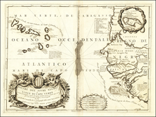
Attractive map of Southern Africa and part of Madagascar, shortly before the first Dutch settlement in the region.
The area shown is from the Congo River basin around the Cape of Good Hope and up the east coast as far as northern present-day Mozambique. Many coastal names are shown, including Mozambique Island which was an important stopover for ships sailing to India and points east. To the north, one of the Ptolemaic lakes thought to be the source of the Nile is shown.
Information on the interior is sparse, reflecting the lack of knowledge the Europeans had about the interior of Africa.
Willem Janszoon Blaeu (1571-1638) was a prominent Dutch geographer and publisher. Born the son of a herring merchant, Blaeu chose not fish but mathematics and astronomy for his focus. He studied with the famous Danish astronomer Tycho Brahe, with whom he honed his instrument and globe making skills. Blaeu set up shop in Amsterdam, where he sold instruments and globes, published maps, and edited the works of intellectuals like Descartes and Hugo Grotius. In 1635, he released his atlas, Theatrum Orbis Terrarum, sive, Atlas novus.
Willem died in 1638. He had two sons, Cornelis (1610-1648) and Joan (1596-1673). Joan trained as a lawyer, but joined his father’s business rather than practice. After his father’s death, the brothers took over their father’s shop and Joan took on his work as hydrographer to the Dutch East India Company. Later in life, Joan would modify and greatly expand his father’s Atlas novus, eventually releasing his masterpiece, the Atlas maior, between 1662 and 1672.
![Colton's Africa [Southern Sheet]](https://storage.googleapis.com/raremaps/img/small/98349.jpg)
![[Orange Free State, Transvaal, Natal and Part of the Cape Colony] Africa do Sul Folha 1 | Estado Livre d'Orange, Natal, e regiones que limitam com o Transvaal e Colonia do Cabo](https://storage.googleapis.com/raremaps/img/small/90963.jpg)