This item has been sold, but you can enter your email address to be notified if another example becomes available.


|
||

|

|
|

|
Stock# 63668
Description
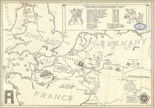
Colossal six-sheet map of the world, published in 1939 or 1940, showing the political boundaries of the world just before the beginning of the Second World War.
The map, in total, is 13 feet wide by 8 and a half feet tall; at this scale, it was doubtless intended as a large wall map for planning and interpretation of global political and military events.
Condition Description
Six separate sheets comprising three columns (by neatlines) and one very large map of the world. Tape stains around the edges of the images on all sheets. Some other minor soiling.
![Historiarum Indicarum Libri XVI [with:] Indiarum Orientalium Occidentaliumque Descriptio. Pet. Maffei Historiae Harum Verissimae, Dedicata.](https://storage.googleapis.com/raremaps/img/small/102793.jpg)

![(World) ЗАПАДНОЕ ПОЛУШАРИЕ | ВОСТОЧНОЕ ПОЛУШАРИЕ [Western Hemisphere | Eastern Hemisphere]](https://storage.googleapis.com/raremaps/img/small/90264.jpg)