|
||

|

|
|

|
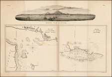
First State of Horsburgh's Second and Substantially Improved Chart of the Coast of China, Philippines and Cochinchina etc.
Finely executed general chart of the South China Sea from Na Trang to Tonkin, Taiwan and Mindoro, with a number of approach views.
This chart replaced an earlier Horsburgh chart of 1811 of the same region. The present chart offered a more accurate charting of the China coast, adding shipping route details important to the Hong Kong trade. The chart also extends to the Philippines, reflecting its importance in the China trade.
Much of the detail given was surveyed and/or compiled under the direction of Lieutenant Daniel Ross, considered the Father of the Indian Surveys, who surveyed the coast of south China between 1806 and 1820.
The publishers imprint reads Published 1st Feb. 1823, by James Horsburgh, Hydrographer to the Hon.ble E.I. Company, according to Act of Parliament.
The need for more accurate charts was forcibly brought home to James Horsburgh on May 30, 1786, when his ship wrecked off the coast of Diego Garcia 'in consequence of an error in her chart' (DNB). For almost the next twenty years Horsburgh gathered information about the sea lanes travelled by the East Indiamen, both from his own observations - most particularly during a seven year period when he commanded a ship called the 'Anna' - and from the work of others. The value and importance of his observations and the resulting charts was swiftly recognized and they were published over a lengthy period, with revisions being made as they were needed.
Horsburgh was rewarded by being elected a member of the Royal Society in March 1806 and, more importantly from a financial point of view, he was appointed hydrographer to the East India Company in October 1810.
Rarity
While later states of the map appear on the market occasionally, the first state is quite rare. This is the first example we have offered for sale.
James Horsburgh (1762 -1836) was a Scottish hydrographer who worked for the British East India Company (EIC) and charted much of China, Southeast Asia, India and contiguous regions in the late eighteenth and early nineteenth centuries.
Horsburgh went to sea at the age of sixteen and was captured and imprisoned by the French at Dunkirk. After his release, he made voyages to the West Indies and Calcutta. In 1786, as first mate in the Atlas, Horsburgh sailed from Batavia to Ceylon and was subsequently shipwrecked on the island of Diego Garcia. This disaster influenced him in his decision to produce accurate maps after he found his way back to India.
EIC hydrographer Alexander Dalrymple published three of Horsburgh’s earliest charts of the Straits of Macassar, of the western Philippines, and of the tract from Dampier's Strait to Batavia. In 1799, Dalrymple published Horsburgh’s Observations on the Eastern Seas on behalf of the EIC.
Meanwhile, Horsburgh continued his sailing career in the Carron, which had been taken up by the British government as a transport to the West Indies and, on his return to England, sailed again for Bombay. There, in April 1798, he was appointed to the command of his old ship, the Anna, and during the next seven years he made two voyages to England, besides several to China, Bengal, and Madras.
On the return trips to England in 1799 and 1801, Horsburgh became acquainted with the London scientific community including Sir Joseph Banks, the astronomer Nevil Maskelyne, and Henry Cavendish. Horsburgh kept barometric records for Cavendish during his voyages from 1802 to 1804, which elucidated the diurnal variation in the open sea between 26°N and 26°S. It was these measurements and his high society contacts that assured Horsburgh nomination and approval as a Fellow of the Royal Society upon his retirement from the sea in 1806.
Horsburgh continued to publish on nautical navigation. In 1806, he released Memoirs Comprising the Navigation to and from China. Next, in 1809 and 1811, Horsburgh finalized Directions for Sailing to and from the East Indies, China, New Holland, Cape of Good Hope, and the interjacent Ports, compiled chiefly from original Journals and Observations made during 21 years' experience in navigating those Seas, also known as the India Directory. These publications made Horsburgh a likely candidate for the position of hydrographer to the EIC, a post he gained in 1810. While serving as hydrographer he revised the Directory, with subsequent editions in 1816-7, 1826-7, and 1836. He also oversaw the compilation and publication of the EIC’s Atlas of India in 1827.
Horsburgh died in 1836. However, his legacy lived on. Friends and admirers in Canton raised a memorial subscription and erected the Horsburgh Lighthouse on Pedro Branca in the Strait of Singapore. With the permission of his children, the Admiralty took up the Directory and released editions in 1841, 1852, 1855, and 1864. After his death and with the demise of the EIC, his charts passed to the Admiralty Hydrographic Office, who reissued them.
![[Philippine Islands, Taiwan, etc] Partie des Isles Philippines; Partie de la Chine; Partie de L'Ile Gilolo; Partie de L'Isle Borneo](https://storage.googleapis.com/raremaps/img/small/93579.jpg)
![[ Hong Kong / Canton ] Nieuwe Pas=Caart Strekkende van Pta Cataon tot Pta Lamtaon langs de kusten von Cochinchina, Tonquin, Quangsi en Quantung bewattende insgelyks het eiland Aynam en die van Macao met dieptens, havens en ankergronden . . .](https://storage.googleapis.com/raremaps/img/small/66695.jpg)
![[ Sichuan and Shaanxi ] Suchuen et Xensi, Provincia seu Praefecturae Regni Sinensis . . .](https://storage.googleapis.com/raremaps/img/small/95627.jpg)
![[Southern Philippine Islands] Carta Dell'Isole Filippine . . . Foglio 1](https://storage.googleapis.com/raremaps/img/small/80315.jpg)