|
||

|

|
|

|
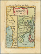
A fine example of the Valk & Schenk edition of Jan Jansson's map of the Sichuan and Shaanxi Provinces, oriented with west at the top.
This attractive and detailed map shows all of the Sichuan (called here 'Suchuan') and Shaanxi ('Xinasi') provinces. The Sichuan capital of Chengdu ('Chingtu') and Chongching ('Chungching') are located to the center-right of the map, while the city of Xi'an ('Sigan'), an ancient captial of China, is located to the right in Shaanxi. The western end of the Great Wall of China passes further to the right, and even further still are the sands of the Gobi Desert, the 'Desertum Europaesis'. The map also features great detail as to the postions of mountains, rivers (including the mighty Yangtze) and villages, all of which are finely engraved.
During the time in which this map was produced, Sichuan and Shaanxi were recovering from the rebellion spear-headed by the peasant leader Zhang Xianzhong(1606-1646), nicknamed "Yellow Tiger", who briefly took control of these regions, declaring himself emperor of the Daxi Dynasty. He met with spirited resistance from the local nobility, and a bloody conflict ensued. While Zhang was overthrown in 1646, it would take several decades for the population and economy of central China to regain its former strength.
The map is based on the groundbreaking work of Martino Martini (1614-61), a legendary Italian Jesuit missionary and scholar. Martini arrived in Beijing in 1644 just as the Ming Dynasty fell to the Manchurian rebels (who formed the Qing Dynasty), and remained in the country until 1651.
Following in the footsteps of his fellow Italian Jesuit Mateo Ricci, Martini sought out the very best maps and surveys of the Chinese Empire. He compiled a series of maps that were by far the most accurate depictions of China to date. Martini's suite of 17 regional maps was first published by Joan Blaeu as the Novus Atlas Sinensis, which accounted for volume 10 of his Atlas Maior (Amsterdam, 1655). Blaeu's arch-rival, Jan Jansson (a.k.a. Jansonius, 1588-1664), issued this edtion shortly thereafter. Martini's work was described by the great German geographer Ferdinand von Richthofen, as:
"the most complete geographical description of China that we possess, and through which Martini has become the father of geographical learning on China."
Indeed, even Jean-Baptiste du Halde's Description…de la Chine (Paris, 1735), published 80 years later, did not fully supercede Martini's work.
The present map is thus one of the foundations of the modern cartography of central China.
Peter Schenk the Elder (1660-1711) moved to Amsterdam in 1675 and began to learn the art of mezzotint. In 1694 he bought some of the copperplate stock of the mapmaker Johannes Janssonius, which allowed him to specialize in the engraving and printing of maps and prints. He split his time between his Amsterdam shop and Leipzig and also sold a considerable volume of materials to London.
Peter Schenk the Elder had three sons. Peter the Younger carried on his father’s business in Leipzig while the other two, Leonard and Jan, worked in Amsterdam. Leonard engraved several maps and also carried on his father’s relationship with engraving plates for the Amsterdam edition of the Histoire de l'Académie Royale des Sciences.
Gerard Valk, or Gerrit Leendertsz Valck (1652-1726) together with his son Leonard, were the only significant publishers of globes in the Netherlands in the eighteenth century, enjoying an almost total monopoly in the first half of the 1700's. Initially an engraver and art dealer, and having worked for map-sellers Christopher Browne and David Loggan in London between 1672 and 1679, Valk established the firm in Amsterdam in 1687. Initially, they published maps and atlases, but in 1700 the company moved the shop to the building previously occupied by map and globe-maker Jodocus Hondius. In 1701, he applied for a charter for making globes and the "Planetolabium", designed by Lotharius Zumbach de Coesfelt (1661-1727), an astronomy lecturer at Leiden University. The Valks produced several editions of 3, 6, 9, 12, 15, 18 and 24-inch diameter terrestrial and celestial globes. The cartography, as stated on the cartouche, is based closely on the celestial atlas Uranographia, published in 1687 by the celebrated Polish astronomer Johannes Hevelius (1611-1687).
Around 1711, when he became a member of the bookseller's guild, Leonard Valk (1675-1746) came into partnership and his name started to appear alongside that of his father on the cartouches of the globes, although the earliest of these, both terrestrial and celestial, still bear the date 1700. Leonard naturally took over the business on his father's death in 1726, and following his own death in 1746 the firm was run by Maria Valk, cousin, and wife to Gerard. By then its days of glory had passed. Leonard Valk died in relative poverty: his wife had to take in the washing of their aunt to make ends meet. The late eighteenth century saw a number of successful reissues by publisher Cornelis Covens (1764-1825), who ran the famous cartographical publishing house of Covens & Mortier (1721-1866) in Amsterdam. This firm was the biggest Dutch one for publishing maps in the 18th century. It was located on the Vijgendam (Fig Dam), the southern part of what is now Dam Square, the central hub of the city. They didn't move out of their building, but they did change addresses. At first in 1795 the whole Dam was rebaptized into Revolution Square, then it got the name Napoleon Square, till in 1813 after Napoleon's fall Covens & Mortier were back again at the Vijgendam.
![Zhuili (Dili) Tu [Geographical Map (of China)] 墬理圖](https://storage.googleapis.com/raremaps/img/small/65048kb.jpg)
![[Macau] Plan de la Ville et du Port de Macao](https://storage.googleapis.com/raremaps/img/small/74702.jpg)