|
||

|

|
|

|
Rare First State of Farmer's "Improved Edition" in Vibrant Original Color
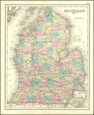
Important early map of Michigan Territory, published by Michigan's most important map maker, John Farmer.
The present map is Farmer's first new map of Michigan Territory since the publication of his 1831 map, which accompanied his Emigrant's Guide, or Pocket Gazetteer of the Surveyed Part of Michigan. In the intervening 4 years, many new towns were established and now appear on this 1835 map for the first time, including:
- Kelamazoo (corrected the following year to Kalamazoo)
- Grand Rapids
- Battle Creek
A very scarce and important map of Michigan Territory, colored by counties. This map shows the lower section of Michigan, roughly to the bottom of Saginaw Bay. It is not to be confused with a map of the same period by Farmer which shows both Michigan and Wisconsin. The fact that Farmer was publishing in Detroit and would have been most aware of new towns popping up makes it quite likely that this is the first appearance of these three, and other, towns.
Kalamazoo was originally platted as Bronson by Titus Bronson in 1831. However, the founder was so unpopular that he was run out of town and the town renamed Kalamazoo in 1836, meaning that this map, which calls the town "Kelamazoo" pre-dates the official name change.
Grand Rapids had estimated population of 50 in 1834 and was not incorporated as a village until 1838.
This up-to-date depiction of the development of Michigan's frontier make this a key map in tracking the history of this region. The principal meridian and base line for Michigan are shown along with township and range numbers for the public land survey of the state.Areas of private (French) claims are shown along the Raisin River and Detroit River.
Inset maps include:
- Straits of Mackinac
- Private Claims at Green Bay Township
- Iowa County near the junction of the Mississippi and Little Platte Rivers.
- Map of Pte. St. Igncace
- Michillimackinac Island
John Farmer's maps of Michigan are among the earliest and most important maps of Michigan and are highly sought after among collectors. Farmer was born in Half Moon, N ew York in 1798, educated near Albany and taught at the Lancastrian School in Albany. He relocated to Michigan in 1821 at the invitation of Governor Cass and the Trustees of the University of Michigan.
Farmer engaged in extensive survey work and published his first map of Michigan in 1826. Over the next 5 years, he was responsible for a total of 12 maps, many of which he engraved himself, including the first map of Detroit. Farmer's early maps were largely influential in promoting the extensive emigration to Michigan that occurred between 1825 and 1840.
Rarity
The map is extremely rare on the market. We note no copies on the market in dealer catalogs or at auction since 1961.
John Farmer first became a school teacher and taught map drafting among other topics in upstate New York.
At the time, Michigan Territory was in need of teachers. In December 1821 the board of University of Michigan in Detroit (still only primary and secondary education) offered Farmer a position as head of the Lancasterian School.
Trained as a draftsman, Farmer supplemented his income by copying surveyor's township maps and selling the maps to new settlers. He also drew for the Treasurer of the United States a map of Michigan’s first real road, which had been funded by the federal government and assisted Orange Risdon in his map of the surveyed part of Michigan. When Risdon’s project stalled, Farmer ended up publishing his own detailed map of the state in 1826.
By 1830, Farmer had created a new large format map of Michigan which had so much detail that the engraving of the map had to be outsourced to engravers in New York City. This Map of the Surveyed Part of the State of Michigan depicts in great detail the southern half of Michigan’s lower peninsula.
Farmer also produced regional maps starting in 1835 when both Michigan and Wisconsin were still mere territories, ontinuously revising them over the years to reflect changes in development. At the time of his death nearly 25 years later he was still producing a Michigan & Wisconsin map, now titled Map of the States of Michigan and Wisconsin, embracing a great part of Iowa and Illinois and the whole mineral region with a chart of the lakes: Exhibiting the sections, the geological formations, and the general topography.
After a few years Farmer sold the publishing rights to his maps to eastern publisher J. H. Colton and turned his attention to mapping new communities and became involved in the formation of a Detroit Board of School Inspectors.
In 1844, Farmer issued the first edition of his The State of Michigan and the Surrounding Country. This map contained extreme detail of every surveyed square mile, every stream, swamp, and every road and trail and would be published by the Farmer family for the next 30 years.
Farmer died March 24, 1859 in Detroit, Michigan. His widow Rachel Farmer and sons Silas, Arthur and John carried on the business for some time afterward. Maps published after John Farmer's death, however, never maintained the detail and currency of his former work.
![[ First map of Michigan Territory published in Europe ] Carte Geographique, Statistique et Historique De Michigan](https://storage.googleapis.com/raremaps/img/small/99266.jpg)