


|
||

|

|
|

|
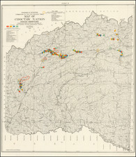
Detailed survey of the lands in Indian Territory occupied by the Creek Indians by agreement with the United States Government.
The map shows the results of the earliest surveys of the watershed of the Canadian River and Red Fork of the Arkansas River in Indian Territory. It extends from Fort Smith to the border with Texas, and was conducted under the direction of Lorenzo Sitgreaves and J.C. Woodruff.
The lands of the Cherokee, Creek, Seminole and Choctaw Indians are located. The map locates numerous forts, including Smith, Coffee, Gibson and Old Fort Holmes, and their connecting wagon roads. Talasee is shown at the site of Tulsa. This map was issued with the "Northern and Western Boundary Line of the Creek Country" report by Sitgreaves and Lt. J.C. Woodruff.
The surveys were made in 1848 and 1850, but the report in which the map was issued wasn't published until 1858.
The present example includes the text report.

![Louisiana [Large-Paper Example]](https://storage.googleapis.com/raremaps/img/small/83278.jpg)
![[Uncaptioned image of two figures seated in front of a tipi, mounted albumen print]](https://storage.googleapis.com/raremaps/img/small/78744.jpg)