|
||

|

|
|

|
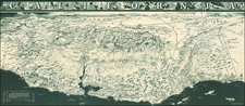
Early State of Kirk Sewall's Scarce Map of Peiping (Beijing).
Pictorial map of central Beijing, published in Beijing by the Peiyang Press.
Sewall's map is richly embellished with illustrations of landmark buildings and black silhouettes of workers, pedestrians and animals, including camel trains. The map depicts three parts of the Beijing: Tartar City, Imperial City (which contains the Forbidden City) and Chinese City.
A number of landmarks are named in both English and Chinese characters. A small pencil note locates the YMCA, near the Capitol Theatre and Foreign Office.
The map is printed in shades of green, yellow, red, blue and white, and outlined in black. It appears to have been published in China for tourists, since it highlights areas of particular interest to travelers including sightseeing attractions, the rail station, hotels, the YMCA, and a street identified as "good for shopping." Of historical interest is the Legation Quarter, where the foreign delegations were clustered. An examination of this section of the map helps to ascertain its publication date.
The map was published shortly after 1928, when the name Peiping first came into use. The German Legation is represented by the black, red and gold Reichsbanner flag, which was banned in 1933. As such, this map was issued between about 1928 and 1933.
The map was designed by John Kirk Sewall, an American illustrator, who created another map detailing the city of Peking proper (1930s), as well as illustrating the popular cookbook, Corinne Lamb's The Chinese Festive Board (1935).
The publisher, the Peiyang Press, was one of the leading printers maps, books and views geared at Western audiences in China during the Republican period. The company was founded in 1924, with offices in Tianjin and Beijing, and operated until the Communist Revolution in 1949. Notable publications included Alice Leighton Cleather and Basil Crump's Buddhism: The Science of Life (1928), Robert M. Duncan's Peiping Municipality and the Diplomatic Quarter (1933), a Chinese-Dutch dictionary (1935) and a 1937 album of black and white photographs of British military exercises in China, celebrating the coronation of George VI. They also published a Map of Tientsin (1941), Frank Dorn's pictorial A Map and History of Peiping and both of John Kirk Sewall's maps of Beijing and environs.
![[Hawaiian Islands] Aloha Airlines The Spirit Moves Us . . .](https://storage.googleapis.com/raremaps/img/small/59216.jpg)
![[Map of the Mount Everest Region] Mahalangur Himal Chomolongma -- Mount Everest](https://storage.googleapis.com/raremaps/img/small/95259.jpg)