|
||

|

|
|

|
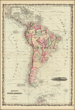
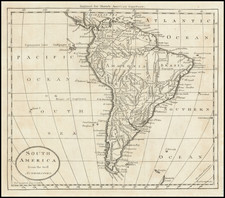
Striking Map of South America from a Curious Spanish Publication
Fine map of South America from Juan Corradi's Descubrimiento y Conquista de la America o Compendio de la Historia General del Nuevo Mundo (1803). The maps for this book were created by a team of cartographers at Spain’s Dirección Hydrográfica, lending importance to an otherwise mundane publication.
Largely unknown until recent years, the map is extraordinarily well-researched for its date and context of illustrating an abridged and translated adaptation of William Robertson’ History of America (1777).
The map is tightly focused on South America, with the Malvinas, or Falklands, included. The Andes form the spine of the landmass, with individual mountains dotting the length of it. Tierra del Fuego is also mountainous, with a volcano in mid-explosion.
Rivers and their tributaries criss-cross the interior, including the Amazon and the Orinoco. However, the regular shapes for lakes and repetitive snakelike winding of some rivers show that Europeans still had much to learn of the continent’s riverine networks, especially in the rainforests of Brazil.
The publication of the Corradi maps
This map was one of three that appeared in Juan Corradi’s translation of Joachin Heinrich Campe’s adaptation of William Robertson’s History of America (1777). The latter was a hugely popular work that was translated, reprinted, pirated, and adapted dozens of times across Europe in the late-eighteenth and nineteenth centuries.
Corradi translated Campe’s German work into a three-volume Spanish set. Rather than reuse existing maps, or adapt Kitchin’s maps made for Robertson into Spanish, Corradi instead acquired amazingly detailed maps for each volume.
- Vol. 1 focuses on the voyages of Columbus and has “Carta Esferica Del Golfo de Mexico e Islas Antillas”
- Vol. 2 discusses the expeditions of Hernán Cortes and has “Carta Esferica Del Reyno De Mexico y parte de la America Setentrional.”
- Vol. 3 focuses on Pizarro, with this map.
While Corradi’s connection to Spain’s hydrographic body, the Dirección, is not clear, it is known who worked on these maps. Under Carlos III (r. 1759-1788), the centuries-old policy of tightly controlling Spain’s geographic knowledge lifted somewhat. It was under Carlos III’s orders that the Dirección was organized, with the initial guidance of Vincent Tofino.
While Carlos III’s son, Carlos IV (r. 1788-1808), returned Spain to a tighter regulation of cartographic content, this map, with its expert makers, did not attract scrutiny. It was produced by Dirección hydrographers Tomás Gonzalez, José María Cardano, Felipe Cardano, and Juan Morata. The Cardanos were the engravers, Morata a draughtsman, and Gonzalez a geographic compiler. This cartographic dream team lent prestige to an otherwise unremarkable publication.
Rarity
The Corradi maps are quite rare on the market. This is the first time we have offered this map in over twenty years.
![Pascaart vertoonende de zeecusten van Chili, Peru, Hispania Nova, Nova Granada, en California…. [Early New Zealand Inset]](https://storage.googleapis.com/raremaps/img/small/65168.jpg)