|
||

|

|
|

|
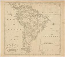
This 1804 map "South America from the Best Authorities," engraved for Jedidiah Morse's "American Gazetteer," represents an early 19th-century depiction of the South American continent. Created in Charleston, Massachusetts, by publisher Samuel Thomas Etheridge, the map illustrates the geographical knowledge and understanding of the era.
The map features the broad regions of Amazonia, Brazil, Paraguay, Chili, Peru, New Granada, Terra Firma, and Guinea, providing a comprehensive view of the continent's physical and political divisions. The term "Terra Firma" in the context of this map refers to the Spanish Main, the mainland coastal region of the Spanish Empire in the Americas during the colonial period. The inclusion of these territories in the map reflects the geopolitical landscape of the early 19th century, a period when European powers exerted significant influence over the region.
Jedidiah Morse, the creator of this map, was a prominent geographer of his time and is often referred to as the "father of American geography." His works were well-respected and widely used as reliable sources of geographic information.
The map also offers a glimpse into the complex and evolving relationship between North and South America in the early 19th century, a time when the United States was expanding its geographical knowledge and influence. As such, it serves as an intriguing testament to the cartographic advancements of the era and the shifting geopolitical dynamics of the Americas.
![(Malaspina Expedition): [Group of six manuscript documents, signed, related to a future assignment for the officers of the Malaspina expedition, including a voyage to chart the coast of Guatemala and to explore Nicaragua, proposed by the viceroy of New Spain]](https://storage.googleapis.com/raremaps/img/small/101838.jpg)