


|
||

|

|
|

|
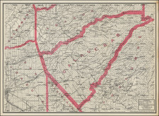
Illustrating Southern California Ranchos
Rare separately issued promotional map of Southern California, published by Rand McNally & Company, one of the earliest maps to focus on Southern California as an economic unit.
This is one of the earliest printed maps to illustrate the concept of "Southern California" as a distinct geographical region.
The map is a remarkable complilation of information, including towns, roads, ranchos, railroad lines, mountains, rivers, etc. Includes many early Southern California place names, showing Orange County, but pre-dating Riverside County.
The map was published in about 1889, although a pencil note on the cover suggests 1885. Orange County is shown on the map, but not in the title.
Rarity
This is the first example of the map we have ever seen. OCLC locates 1 example dated 1888 (UCLA) and 1 exampled dated 1893 (British Library). By 1897, the name "Orange County" had been added to the title (Huntington Library).
We note one example at auction in 2007 (dated 1888, ex-Dawson Booksellers, Los Angeles).
A later edition, including Riverside County, was apparently issued in 1906, although we locate only the copyright depository copy with the Library of Congress.
Rand McNally & Co. is a large American map and navigation company best known for its annual atlases. The company got its start in 1856, when William Rand opened a print shop in Chicago. He was joined in 1858 by a new employee, Andrew McNally. Together, the men established their namesake company in 1868. Originally, the company was intended to print the tickets and timetables for the trains running to and through Chicago; their first railway guide was published in 1869.
By 1870, they had shifted from just printing to publishing directories, travel guides, and newspapers. Their first map appeared in 1872 in a railway guide. The map was produced using a new wax engraving method, a cheaper process that gave the company an edge.
By 1880 Rand McNally had entered the education market with globes, wall maps, and geography texts for students. In 1923, Rand McNally published the first Goode’s World Atlas, named after its editor, Dr. J. Paul Goode. For generations afterward, this would be the standard classroom atlas.
In 1899, William Rand left the company, but McNally and his family remained, controlling the company for over a century. In 1904, they published their first road map intended for automobiles and by 1907 were publishing Photo-Auto Guides, which combined photography and mapping to help drivers. In 1924, they produced the Auto Chum, a precursor to their famous road atlases. Rand McNally would remain the leader in road maps and atlases throughout the twentieth century.
In 1937, Rand McNally opened its first store in New York City. Ever on the frontier of technology, Rand McNally pioneered the scribing process for printing tickets in 1958 and printed their first full-color road atlas in 1960. Arthur Robinson developed his now-famous projection of Rand McNally in 1969. By the 1980s, the company was exploring digital reproduction and digital databases of maps for truckers. In the 1990s, they lead the charge to develop trip-planning software and websites. Today, most of its products are available online or in a digital format, including maps for tablets and phones.
![[ Upper California ] Map of the Californias By T.J. Farnham](https://storage.googleapis.com/raremaps/img/small/99592.jpg)
![[ Climatology ] Map of California Illustrating Its Climatology -- Comparative Area -- Rail Lines -- Compiled From Official and Authentic Sources By The Southern Pacific . . . 1903](https://storage.googleapis.com/raremaps/img/small/82610.jpg)
![[ Cabo San Lucas, Southern Baja ] Delineatio Nova Et Vera Partis Australis Novi Mexici, cum Australi Parte Insulae Californiae Saeculo Priori ab Hispnis Detectae.](https://storage.googleapis.com/raremaps/img/small/95666.jpg)