


|
||

|

|
|

|
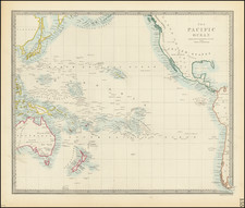
The Myth of Anian
Very rare and fantastic representation of the Land of Iesso and the Strait of Anian, a massive landmass thought to nearly connect California to Asia. This myth evolved over the centuries, representing at times a simple extension of Japan and at others a connection through the Pacific. It is uncommon to see maps focused solely on the strait of Anian.
The map shows the land of Iesso (sometimes spelled Yesso), separated from Asia by the de Vries straight. The Strait first appeared on maps in the 1560s, and its altitude changed drastically over time. While initially the Strait of Anian was placed near the present-day Bering Strait, by the start of the eighteenth century it had migrated southwards to the latitude of California. It would slowly be chipped away from during the rest of that century following English, Russian, and other expeditions to the north Pacific.
This woodblock was published as part of Thomas Campanius's Kort Beskrifning Om provincien Nya Swerige uti America, a history of Swedish colonization in the Americas. The book is based on Thomas Campanius's grandfathers important early works in the Swedish colony, where he provided translations for a now-lost Indian language and took the first recorded weather measurements on the continent. A large portion of the book deals with the Native population, and the inclusion of this map may be so as to help one understand how humans arrived in the Americas. Thomas Campanius's name is oftentimes misnoted as Thomas Campanius Holm, shortening Holmensis, the Latin name for Stockholm.
![[ First State of the First Map of America ] Novae Insulae XVII Nova Tabula](https://storage.googleapis.com/raremaps/img/small/94609.jpg)
![[Berkeley] This Is The Map of Berkeley Town Its Streets Go Winding Up & Down An Oak-Covered Campus It Wears For A Crown With People & Places of Renown](https://storage.googleapis.com/raremaps/img/small/97201.jpg)