|
||

|

|
|

|
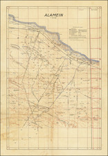
Contemporary Survey of the Wrecked Mulberry Harbor at Omaha Beach - Famously Destroyed in a Storm Shortly after the D-Day Landings.
A large survey of the damaged Mulberry Harbor "A" at Omaha Beach. The harbor was projected to be one of two temporary harbors constructed at the D-Day landing beaches Omaha and Gold; they were intended to facilitate the initial breakout from Normandy before ports such as Cherbourg could be captured and made usable.
On the 19th - 22nd of June a rare, Force 6 -7 storm struck Normandy, washing more than 800 vessels onto the beaches. This storm wreaked havoc on the American Mulberry harbor (which was less complete and generally more exposed and vulnerable than the British Mulberry which survived the storm). The storm surge destroyed 20 of the 30 caissons at Omaha Beach forcing the Allies to abandon the American harbor.
This map shows the Royal Navy survey of the area and was certainly part of the decision making as to whether to attempt to salvage the harbor or abandon it to rely on Gold Beach and the future ports to be captured by the Allies.
The key includes the following symbols: Blockships, Vessels moored afloat, Phoenix, Ruined Phoenix, Phoenixes to be placed, Blockships to be placed, Proposed lines of Coaster hauling-off buoys, Beach marks.
The map is marked "Secret".
![(France under Clovis) Franciae Status sub Regibus Primae Stirpis, ex Observationibus D. Mart. Bouquet Benedictini atque ex Dissertationibus D. Lebeuf Canonici Autis . . . [The State of France under its First Kings. . .]](https://storage.googleapis.com/raremaps/img/small/89714.jpg)
![(World War II) [Iwo Jima Aerial Reconnaissance Photograph, March 8, 1945]](https://storage.googleapis.com/raremaps/img/small/83776.jpg)