|
||

|

|
|

|
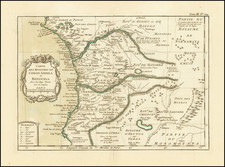
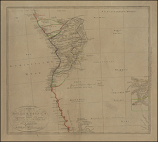
A Map of Mauritania During the Period of "French Pacification"
Rare separately published map of Mauritania, based upon a series of astronomical observations made between 1905 and 1922, by various French military surveyors.
The title provides and extensive list of the surveys undertaken. The map locates:
- Railroads completed
- Railroads under construction
- Various Roads
- Telegraph lines
- Various town and city sizes
- Water
The map also includes a glossary of local words translated to French
Mauritania
In 1442, Portuguese mariners rounded Cape Blanco (Cape Nouâdhibou) and six years later founded the fort of Arguin, which became an important trading point for obtaining gold, gum arabic, and slaves. These same commodities later drew Spanish, then Dutch trade to the coast in the 17th century when gum arabic was found to be useful in textile manufacture.
In the 19th Century, the French obtained significant concessions on the Saharan coast through various European treaties. French claims to sovereignty over the hinterland were regularly disputed by the leaders (referred to as “amirs” or “commanders” by the French) of the regions of Trarza and, to the east, Brakna—named for the two Ḥassānī lineages that dominated the Sénégal River valley—who claimed territory on both sides of the Sénégal River.
The French governor of the region, Col. Louis Faidherbe, entered into treaty relations with the amirs in 1858, but France made little effort to exert control over southern Mauritania until the opening years of the 20th century. The “pacification” of Mauritania, as it was styled by the French military, continued until 1912, and the final battle to subdue a Reguibat band took place in 1934.
Rarity
We locate no other recorded examples of the map.
![[ Sierra Leone to Côte d'Ivoire ] Pas-caert vande Gryen-Cust en Adaows Qua Quaas Tuhessen de Serraliones en C. de Tres Puntas . . . .](https://storage.googleapis.com/raremaps/img/small/99332.jpg)