
This item has been sold, but you can enter your email address to be notified if another example becomes available.


|
||

|

|
|

|
Stock# 61451
Description
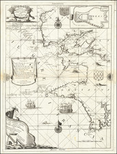
Striking full color example of Wagenhaer's map the French Coastline, from Bordeaux to Poictou, with the Islands of Ile de Re and Oleron, centered on La Rochelle
Wagenhaer was a Dutch pilot who produced the first set of effective navigational charts, under the title Spiegel der Zeevaerdt.
These gorgeous charts, engraved by Baptist and Jan van Doetecum, embody the latest contemporary knowledge of navigation and position finding and set the standard which was followed for more than a century. Waghenaer's charts are magnificent works of art, which are highly sought after by collectors.
![[Biscaya] De Zeecusten van Vrancrijck en Biscaijen tuschen Arcachon en de C. de Machicaco](https://storage.googleapis.com/raremaps/img/small/84355.jpg)
![[Siege of Poitiers] Vero disegno della nobilissima Citta di Poitiers, nella Gallia Celtica, Soggi Aquitania detta, e, da Ceare Pictones Populi. Con il tremendo assedio de essa, postolio alli xxvij, di Luglio di questo anno M.D. Lxix da GAsparo Coligni S. di Ciatiglion gia Armiraglio di Francia dal Prencipe di Navarra et di Conde, et altri SS. Cavalieri Francesi Vasalli del Re et Capi della setta Ugonotta. con altri d’Alamagna condotti dal Conte di Mansfelt. et tenuto sino alli vy di Settembre. . . .](https://storage.googleapis.com/raremaps/img/small/61361sb.jpg)
