|
||

|

|
|

|
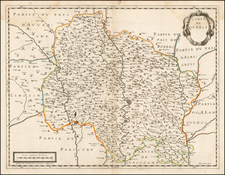
Very attractively designed and colored map showing southwestern France, from the Spanish border northwards to Bourdeaux. While the primary focus of the map is on the region now known as Aquitaine, detail stretches as far eastwards as the Languedoc. Many major cities can be located on the map, including Toulouse, Bourdeaux, Bayonne, Cahors, and Narbonne. The Pyrenees rise up in the south of the map, the forests of the Pays Basque and Les Landes are shown in the west, and the course of the Garonne and Gironde can be traced.
The map includes an attractive cartouche in the upper right showing the coats of arms of cities in the region, including Foix, Bigort, Bearn, and Armagnac, although some are left blank. A legend and a scale bar showing the different units of measurement used in the region are shown in the lower right.
This map was printed in Amsterdam by Pierre Mortier, following a previous design by the French cartographer Guillaume de L'Isle.
Guillaume De L'Isle (1675-1726) is probably the greatest figure in French cartography. Having learned geography from his father Claude, by the age of eight or nine he could draw maps to demonstrate ancient history. He studied mathematics and astronomy under Cassini, from whom he received a superb grounding in scientific cartography—the hallmark of his work. His first atlas was published in ca. 1700. In 1702 he was elected a member of the Academie Royale des Sciences and in 1718 he became Premier Geographe du Roi.
De L'Isle's work was important as marking a transition from the maps of the Dutch school, which were highly decorative and artistically-orientated, to a more scientific approach. He reduced the importance given to the decorative elements in maps, and emphasized the scientific base on which they were constructed. His maps of the newly explored parts of the world reflect the most up-to-date information available and did not contain fanciful detail in the absence of solid information. It can be fairly said that he was truly the father of the modern school of cartography at the commercial level.
De L’Isle also played a prominent part in the recalculation of latitude and longitude, based on the most recent celestial observations. His major contribution was in collating and incorporating this latitudinal and longitudinal information in his maps, setting a new standard of accuracy, quickly followed by many of his contemporaries. Guillaume De L’Isle’s work was widely copied by other mapmakers of the period, including Chatelain, Covens & Mortier, and Albrizzi.
Pierre, or Pieter, Mortier (1661-1711) was a Dutch engraver, son of a French refugee. He was born in Leiden. In 1690 he was granted a privilege to publish French maps in Dutch lands. In 1693 he released the first and accompanying volume of the Neptune Francois. The third followed in 1700. His son, Cornelis (1699-1783), would partner with Johannes Covens I, creating one of the most important map publishing companies of the eighteenth century.
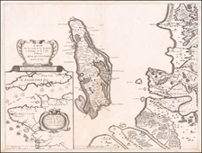
![[Biscaya] De Zeecusten van Vrancrijck en Biscaijen tuschen Arcachon en de C. de Machicaco](https://storage.googleapis.com/raremaps/img/small/84355.jpg)